Route Editor

| Guide | ♦ | 1 Triplog | 0 Topics |
details | drive | permit | forecast | route |
stats |
photos | triplog | topics | location |
| 53 | 1 | 0 |
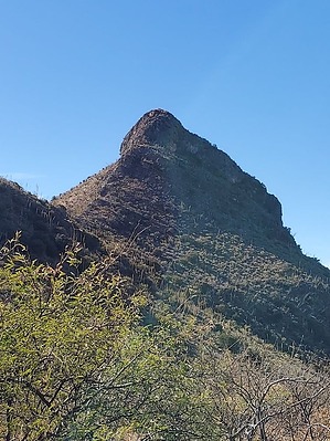
Nobody was sitting on the throne when I arrived! by Mike_W  Overview OverviewDevil's Throne, also known as Peak 5359, has an elevation of 5359 feet and is within a mile radius of the Whipple Observatory Picnic area on Mt Hopkins Rd, Tubac, AZ 85646. There's an old mining road that will get you 2/3 of the way up and cover 2/3 of the distance to the summit. From the end of the road, there are use-trails that will get you the rest of the way. Some steep climbing sections on Peak 5359 are not for beginners. An experienced hiker should feel comfortable to reach the summit without ropes. Please do not attempt this hike if you don't know what you're doing. Warning Some steep sections may involve climbing using your arms and legs. I thought the climbing section was slightly more challenging than the climb on Elephant Head but shorter.
If you parked at the lower part of the 4x4 road using my instructions, you should see a green metal electrical box which is a nice reference for the parking area. If you parked elsewhere, see my posted route and hike to this electrical box. There is no need to drive up the 4x4 road because it's fairly easy to walk and there aren't any other good parking areas that I'm aware of. From the green electrical box, walk roughly 0.9 miles up the fairly well-maintained 4x4 road. If you see any branches/splits in the road, always stay to the right. After 0.9 miles you should be on a saddle and see a cul-de-sac. At the end of the cul-de-sac, there's a use-trail that continues in the direction of the peak. There are two other nearby peaks that I hiked in conjunction with Devil's Throne that you should be able to see from this area and you may want to include them also on your hike. If you look to the north you will see Peak 5133 which is only 200 feet in elevation higher than the saddle and is a bushwhack without a use-trail. If you look to the southwest you will see Peak 5173 which is roughly 200 feet lower than the Devil's Throne to the west of it. I didn't see any trails going to either of those secondary peaks which would involve a light bushwhack. I was able to zig-zag around brush and cactus and summit these high points fairly easily. See my route for more info. This guide will continue to describe getting to the Peak 5359 summit. The use-trail will continue around the north side of Peak 5173. You should have a view already of Peak 5359 and it will look very steep from this point and difficult to climb without ropes. But, as you get closer, you might find that it's not quite as bad as it looks. Follow the use-trail west to the saddle to the east of Peak 5359. At times the trail will rise or fall along the north slope of Peak 5173. While going around the peak, I found a few cairns which directed me up a steep section. Eventually, I got to the saddle and saw a thin rocky ridgeline. From here, it looked easier than from the view I had further away. While climbing, I stayed close to the center ridgeline and took the path of least resistance. There was no point where I felt like I had to take any risk. If you feel like a section is too steep, look for another easier way. Always keep in mind that you need to go down, so don't go up anything that you feel you might have trouble going down. At times, there are some cliffs to the north and south of the ridgeline. You should not need to get close to any of these cliffs. Also, remember that there are usually 2 or 3 good ways to go and a very large number of bad ways to go. There's a long narrow relatively flat area at the summit. I found a registry here in a rock pile and signed it. You'll see views of the Whipple Observatory and Devil's Cashbox to the northwest, Elephant Head to the north, and Mt Hopkins to the northeast. Mt Wrightson will be mostly behind Mt Hopkins but I believe I was able to see part of the summit just to the right of Mt Hopkins. On the way down, you should be able to take the same general route with some minor variations. Again, nothing here should be dangerous. If you see a steep slope in front of you, weave left or right and look for a better route. Check out the Official Route and Triplog. Leave No Trace and +Add a Triplog after your hike to support this local community. | |||||||||||||||||||||||||||||||||||||||||||||||||||||||||||||||||||||||||||||||||||||||||||||||