Route Editor

| Guide | ♦ | 33 Triplogs | 0 Topics |
details | drive | permit | forecast | route |
stats |
photos | triplogs | topics | location |
| 72 | 33 | 0 |
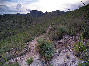
no reservations needed by PrestonSands   Overview OverviewThe Foothills Loop Trail at Kartchner Caverns State Park takes one through the limestone foothills of the Whetstone Mountains. High desert plant life, and views of the surrounding mountain ranges are the attractions on this easy hike. This write-up describes a clockwise loop. The mileage listed includes the mountain viewpoint spur. Use of the Foothills Loop Trail requires the admission fee to Kartchner Caverns State Park. The Park's entrance gates are open from 7 am until 6 pm daily. Off-trail hiking within the Park's boundaries is forbidden.
The Foothills Loop Trail begins at the northwest corner of the Visitor's Center parking lot. A sign marks the starting point. The trail heads west through mesquite scrub, towards the layered limestone cliffs of the Whetstones. After crossing Guindani Wash, the Foothills Loop Trail reaches a "T" intersection with the Guindani Trail at 0.6 miles. Go right, and cross another dry wash. The trail turns north, climbing the rocky hill that houses Kartchner Caverns. The trail crests a saddle at one mile, among prolific ocotillo and shindagger agave, then crosses gray limestone slopes to a second saddle at 1.4 miles. From the second saddle, a marked side trail leads west to the Foothill Loop Trail's high point atop a 5078-foot hill, where one finds a nice view of the surrounding area. Beyond the second saddle, the trail travels east and then south to descend from the Whetstone foothills, passing another marked spur that leads to prehistoric grinding holes in exposed bedrock. Continuing south, the trail crosses a park maintenance road, before dropping into Guindani Wash, which it follows upstream. Soon after crossing underneath the cavern tram bridge, the Foothills Loop Trail rejoins itself near its beginning. Turn left to reach the parking lot. Gate Policy: If a gate is closed upon arrival, leave it closed after you go through. If it is open, leave it open. Leaving a closed gate open may put cattle in danger. Closing an open gate may cut them off from water. Please be respectful, leave gates as found. The exception is signage on the gate directing you otherwise.
Check out the Official Route and Triplogs. Leave No Trace and +Add a Triplog after your hike to support this local community. | ||||||||||||||||||||||||||||||||||||||||||||||||||||||||||||||||||||||||||||||||||||||||||||||||