username
X
password
register
for free!
help


Iron Mountain 7131 - Manitou Springs, CO

Guide 1 Triplog  0 Topics
  4 of 5  
Fav
Wish
0
details
drive
no permit
forecast
route  
stats
photos
triplog
topics
location
14 1 0
Statistics
tap row or icons for details
Difficulty 2 of 5
Route Finding 1 of 5
Distance Round Trip 3.1 miles
Trailhead Elevation 6,616 feet
Elevation Gain 488 feet
Accumulated Gain 509 feet
Avg Time Round Trip 1.5 hours
Kokopelli Seeds 5.65
 Interest Seasonal Creek & Peak
 Backpack Possible - Not Popular
unreported if dogs are allowed
editedit > ops > dogs to adjust
feature photo
Photos Viewed All MineFollowing
14  2023-12-01 Mike_W
Author
author avatar Guides 104
Routes 256
Photos 16,118
Trips 528 map ( 2,863 miles )
Age 53 Male Gender
Location Tucson, AZ
Historical Weather
Trailhead Forecast
Radar Map
Expand Map
Preferred Oct, Nov, Feb, Mar → 9 AM
Seasons   Autumn to Spring
Sun  5:32am - 6:24pm
Official Route
 
0 Alternative


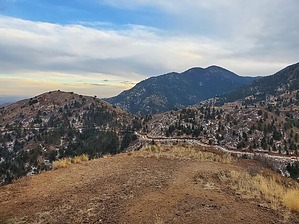
Red mountain's younger sister
by Mike_W

 
Overview
Iron Mountain is a small mountain just south of Manitou Springs, Colorado, which has an elevation of 7,131 feet. It is an easy hike which is fine for beginners. From the top of Iron Mountain, there are some nice views of the town of Manitou Springs below. To the west, there are views of Red Mountain, the Manitou Incline, and Pikes Peak in the far distance.


Hike
Assuming you parked on the east side of the road, you'll want to cross over to the west side of the road and look for the Intemann trail. On the east side of the road is a sign that says "Paul Intemann Memorial Nature Trail, est. 1987". On the west side of the road, you will see some steps leading up to a sign which is 20 feet from the road. This is the direction that you will want to go to get to Iron Mountain.
remove free decal offer
The very beginning of the trail passes pretty close to some private property and some homes are nearby. Then, a set of stairs lead down into a canyon and across going up the canyon. From here, and for the next 1/2 mile, the trail gradually goes uphill and then flattens out after that. You may see some deer on or around the trail as I did in December of 2023. The trail widens and runs into a nicely graded road but I don't believe any motor vehicles are allowed here as these roads don't seem to connect to any private property. The trail will wrap around a small mountain which will be on your left. That mountain is called Sheep Mountain (elev 7160) and there is no trail leading to it. That mountain should not be confused with the much higher Sheep Mountain which is about 3 air miles to the west and has an elevation of about 9,800 feet. Next, follow the road around the "lower" Sheep Mountain and you will see a junction. Stay left, which will lead you to the road going up to the top of Iron Mountain.

From the top, you will see some nice views of the town of Manitou Springs. Looking west and a little bit north, only 1/2 mile away, you will see the top of Red Mountain which is about 200 feet higher than Iron Mountain. Looking beyond Red Mountain you should be able to see the Manitou Incline and possibly some sections of Barr trail #620. If you look way up you may be able to see Pikes Peak, but when I was here the sky was very cloudy and there may have been snow way up there blocking the view.

Return the same way you came to finish your hike.

2023-12-08 Mike_W


    Check out the Official Route and Triplog.
    Leave No Trace and +Add a Triplog after your hike to support this local community.
    WARNING! Hiking and outdoor related sports can be dangerous. Be responsible and prepare for the trip. Study the area you are entering and plan accordingly. Dress for the current and unexpected weather changes. Take plenty of water. Never go alone. Make an itinerary with your plan(s), route(s), destination(s) and expected return time. Give your itinerary to trusted family and/or friends.

     Permit $$
    None


     Directions
    or
     Road
    Paved - Car Okay

    To hike
    From the center of the town of Manitou Springs, Colorado, take Manitou Ave east for roughly 0.8 miles. Turn right onto Crystal Park Rd and continue for 1.5 miles. Look for the Intemann trailhead which crosses the road. There are 3 or 4 free spots for parking on the east side of the road.

    Intemann Trailhead
    Colorado Springs, CO 80829
    page created by Mike_W on Dec 08 2023 11:44 am
     90+° 8am - 6pm kills
    helpcorrectionissue

    end of page marker