username
X
password
register
for free!
help
  🔥

Old West Boulder Canyon, AZ

Guide 1 Triplog  0 Topics
  2 of 5  
Fav
Wish
0
details
drive
no permit
forecast
🔥
route  
stats
photos
triplog
topics
location
5 1 0
Statistics
tap row or icons for details
Difficulty 1.5 of 5
Route Finding 1 of 5
Distance One Way 2.24 miles
Trailhead Elevation 4,463 feet
Elevation Gain -1,885 feet
Accumulated Gain 11 feet
Avg Time One Way 1.5 hours
Kokopelli Seeds 2.28
 Interest Off-Trail Hiking & Seasonal Creek
 Backpack Possible - Not Popular
feature photo
Photos Viewed All MineFollowing
5  2023-12-27
Old West Boulder Canyon Ridge
pseudalpine
Author
author avatar Guides 59
Routes 1,100
Photos 1,191
Trips 1,290 map ( 9,859 miles )
Age Male Gender
Location Arizona
Historical Weather
Trailhead Forecast
Radar Map
Expand Map
Preferred Nov, Dec, Jan, Feb → 7 AM
Seasons   Autumn to Spring
Sun  6:02am - 6:47pm
Official Route
 
1 Alternative
 
Historic Fire Perimetersacres
🔥 2024 Siphon Fire35.9 mi*
🔥 2020 Superstition Fire9.6k
🔥 View (All) - over Official Route 🔥
*perimeter length in miles


remove free decal offer
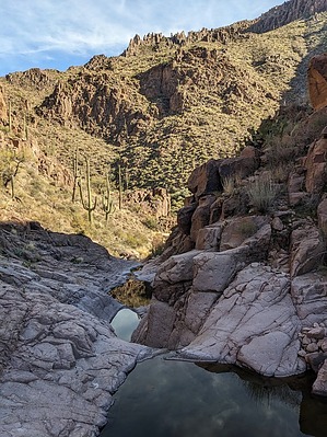
An Aged Hanging Valley
by pseudalpine

Overview
A so-called connector route that descends (or ascends) the canyon located between the Superstition Ridgeline and West Boulder Canyon. I'd postulate that most trekkers would likely utilize this as a one-way section hike when completing loops in the area.


Hike
The western end of the official route leaves the Superstition Ridgeline near Peak 4562. One must steeply descend a northeast-facing slope to gain the rocky wash. From there, one just follows the creek bed mainly east to the confluence with West Boulder Canyon. There's a natural arch on hiker's left (north) about halfway down and the canyon becomes more appealing the closer one gets to the coalescence downstream about a mile from Willow Spring.

2024-02-05 pseudalpine


    Check out the Official Route and Triplog.
    Leave No Trace and +Add a Triplog after your hike to support this local community.

    One-Way Notice
    This hike is listed as One-Way.

    When hiking several trails on a single "hike", log it with a generic name that describes the hike. Then link the trails traveled, check out the example.
    WARNING! Hiking and outdoor related sports can be dangerous. Be responsible and prepare for the trip. Study the area you are entering and plan accordingly. Dress for the current and unexpected weather changes. Take plenty of water. Never go alone. Make an itinerary with your plan(s), route(s), destination(s) and expected return time. Give your itinerary to trusted family and/or friends.

     Permit $$
    None


     Directions
    or
     Road
    Connector trail - Not Applicable

    To hike
    Starts/ends at about the 4.5-mile mark from Lost Dutchman State Park, just east of where the trail completes its only major sweeping curve around upper Broadway Canyon.
    page created by pseudalpine on Feb 05 2024 5:09 pm
     90+° 8am - 6pm kills
    helpcorrectionissue

    end of page marker