 Route Editor

| Guide | ♦ | 13 Triplogs | 1 Topic |
details | drive | permit | forecast | 🔥 route |
stats |
photos | triplogs | topic | location |
| 39 | 13 | 1 |
Challenging by arizonaheat  Stats Down thru WBC proper From: Superstition Ridgeline (2.25mi to Carney TH) To: Dutchman Trail #104 (4.7mi to First Water TH) Guide: Reads as a 10.35 mi / 2280 AEG Shuttle Fritzski wrote: I would recommend this trail (or lack thereof) to that masochistic someone looking for a challenge that has exhausted almost everything else on his/her list. I say this because although your ultimate goal, Willow Springs, may be really neat (I wouldn't know, I didn't make it), getting there is a bear, to say the least... He also stated: I'm being generous when I say that every so often a hint of what once was a trail would appear, only to beg the question of whoever else was insane enough to be down in this jungle.
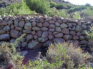
All the above statements are 100% correct. Well yesterday, 12/06/02, this masochistic insane nut and three other masochistic insane nuts that go by the handles of Ally, Cactuscat, and Jmzblond, met at First Water Trailhead at 5:15 AM, left a vehicle, piled into another vehicle, and headed for Carney Springs Trailhead, to make an assault on West Boulder Canyon from Carney Springs to First Water. We were on the trail to West Boulder Saddle at 6:15 AM, marching toward our destination, in the dark. We stopped and took in an awesome sunrise, on our ascent toward West Boulder Saddle. At West Boulder Saddle we enjoyed a short break and a snack before the assault began. With Cactuscat taking the lead we followed the Superstition Ridgeline Trail for a quarter mile or so before finding what looked like as good a place as any to drop into the deep dark abyss and jungle (yes a true jungle in the desert) below, known as West Boulder Canyon. We slowly and cautiously worked our way down into the bottom of the drainage and began working our way down the canyon. We were able to follow the bottom of the drainage for a while, then wham, a thicket of jungle a snake couldn't slither through. It was then necessary to work up the side of the canyon a way until we found a game trail to follow. By the looks of the prickly pear, Javalina were the main users of this trail, the prickly pear has been munched on big time. After following this route for a while, Jmzblond, with the rest of us concurring, decided it was time to drop into the bottom of the drainage for another go of it. It was awesome inside the drainage, we were all awestruck with the beauty, the rock formations, and the numerous pools of water left from the recent rain. It was a true sight to behold, we were like a bunch of young kids out exploring and discovering. Our own private playground. Soon we ran into the jungle barrier again and options for an exit to get up on the canyon walls looked grim, to say the least. After scoping things out I thought I spotted what may be a possible exit, but it wouldn't be easy. Being the masochistic insane nuts we are we decided to give it a go. Taking the lead, I dropped to my hands and knees and began crawling through the thicket of catclaw and various other forms of thorny, pokey things. (It is amazing how far your skin can stretch when catclaw grabs it). We eventually crawled through to a point where we could at least stand up to whack the bush. Alas, we finally found ourselves on a fairly steep sidewall of the canyon free of the jungle thicket. We thought whew finally back to some halfway easy-going, but you know what happens when you let your guard down? Well, I will tell you. A prickly pear cactus will jump out of nowhere and viciously attack one of your hiking companions. An attack so vicious that it requires the removal of one's... ( never mind). Let us just say it required surgical removal with tweezers, blood was drawn and PURPLE was the color du jour. We checked our progress to this point and found our pace since dropping into West Boulder Canyon, was a foot-blistering 0.5 miles per hour. We were now about 0.75 miles from Adolph Ruth's camp, rock corral, and Willow Springs. The story was about the same the rest of the way to Willow Springs. We found the point where we think Fritzski said screw it, and it was easy to understand why, but alas our crawling skills had been honed earlier in the trip, a short crawl and a whack and we were home free. After this point, things open up and it is an easy shot to the rock corral and Willow Springs. The rock corral is an unbelievable sight. I was surprised by how large it is. The amount of work that went into it is mind-boggling. The corral is heavily overgrown and would be easy to miss if you aren't paying attention. From the corral to Willow Spring is less than a tenth of a mile. We ate lunch at Willow Spring and Cactuscat and I drew water with our filters. The water in many of the potholes along the way looked better. The spring is surrounded by cattails and flows over the rock to the lone willow that is deader than a doorknob. The woodpeckers have obliterated it. However, new shoots are making their way up. From Willow Spring we basically stayed in the drainage to a point, where Palomino Mtn. And Dead Woman's Cave came into view. We then exited to the bank where we found a trail that had us on the Lost Dutchman Trail in short order. We were at First Water Trailhead at 3:30. This was a very challenging hike involving boulder hopping the entire length of the canyon, bushwhacking a good part of it, and crawling, the only thing we didn't have to do was crawl on our bellies. We all had a blast. If you ever consider doing this hike just remember you are totally on your own once you drop into West Boulder Canyon, you aren't going to find any kind of a trail, other than game trails and there aren't going to be cairns to show you the way. It is you, your skills, and the canyon. West Boulder Canyon may have taken blood from us all, but we, the Masochistic Insane Nut Kokopelli's WON!!!! WAHOOO!!!!!!!!!! Check out the Official Route and Triplogs. Leave No Trace and +Add a Triplog after your hike to support this local community. One-Way Notice This hike is listed as One-Way. When hiking several trails on a single "hike", log it with a generic name that describes the hike. Then link the trails traveled, check out the example. | ||||||||||||||||||||||||||||||||||||||||||||||||||||||||||||||||||||||||||||||||||||||||||||||||||||||||||||||||||||||||||||||||||||||||||||||||||||||||||||||||||||||||||||||||||||||||||||||||||||||||||||||||||||||||


