Overview
If one happens to be hiking in the South Maricopa Mountains and in the vicinity of Big Horn BM 3183, this is an almost commensurable bonus peak that can be summited also.
Hike
The official route for Big Horn BM 3183 splits at what desert_boonie labels the 2.28-mile turn. The route to Peak 2878 is a third option besides the posted black and red routes.
One continues from the split, bearing northeast, generally following the black route for another quarter mile. I found the upper right bank (east side) of the wash that originates from the saddle between Peak 2878 and Big Horn to be easier than the sandy arroyo. After about a half mile, there is a shallow side canyon that allows one to more easily gain the southwestern ridgeline that can be hiked to the summit. There are sheep trails on the northwest slopes of Peak 2878 that can be descended (or ascended, if hiking a CW loop) to the saddle between the two peaks.
When hiking several trails on a single "hike", log it with a generic name that describes the hike. Then link the trails traveled, check out the example.
WARNING! Hiking and outdoor related sports can be dangerous. Be responsible and prepare for the trip. Study the area you are entering and plan accordingly. Dress for the current and unexpected weather changes. Take plenty of water. Never go alone. Make an itinerary with your plan(s), route(s), destination(s) and expected return time. Give your itinerary to trusted family and/or friends.
 Route Editor

 Overview
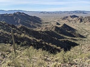


