Route Editor

| Guide | ♦ | 2 Triplogs | 0 Topics |
details | drive | no permit | forecast | 🔥 route |
stats |
photos | triplogs | topics | location |
| 4 | 2 | 0 |
Canyons are inherently risky. Flash floods occur without notice on sunny days. Technical skills & surrounding topography knowledge required yet does not eliminate risk.
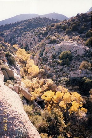
Golden Gem (albeit small) by pseudalpine   This mini slot canyon was termed The Golden Narrows around the late nineties/early Aughts because of the Aureate Cottonwood and Sycamore leaves bursting with Autumn color each year. Of course, others have hiked this canyon before and indigenous humans likely took refuge from the heat in this granite passage well before all of us. One source assigns it the dull name of Campaign Creek, boring! It's also ranked as 3B I (v2a2 I) or more simply, easy. One tricky part can be somewhat challenging, especially considering that most of the depressions seem to have been filled with sand and gravel since the Woodbury Fire. A single rap ring is at this steepest descent (maybe 20 feet) and keeps one away from the worst quicksand and mud slogging. It's also possible to carefully downclimb this spot when it's dryer. This mini slot canyon was termed The Golden Narrows around the late nineties/early Aughts because of the Aureate Cottonwood and Sycamore leaves bursting with Autumn color each year. Of course, others have hiked this canyon before and indigenous humans likely took refuge from the heat in this granite passage well before all of us. One source assigns it the dull name of Campaign Creek, boring! It's also ranked as 3B I (v2a2 I) or more simply, easy. One tricky part can be somewhat challenging, especially considering that most of the depressions seem to have been filled with sand and gravel since the Woodbury Fire. A single rap ring is at this steepest descent (maybe 20 feet) and keeps one away from the worst quicksand and mud slogging. It's also possible to carefully downclimb this spot when it's dryer.For the loop, I've always entered it from above and returned via the JB Road (449A) because most of the good camps are south of the narrows. This is how the Official Route depicts the loop, but hiking the road first is probably more common. There are more parking options at the lower, north end of the slot and this would also avoid having to drive the worst, rough hilly section of the JB Road. Side-by-sides have been wheeling up the creek bed to the lowest narrows ever since the major flash floods post-Woodbury Fire and also from some big storms a few summers ago, both of which scoured out an easier 4x4 access. So, if you're expecting some solitude, make sure to stop for a break near the Rocky Balboa Saguaro and not near the northern terminus.
Danger of Flash Flooding during inclement weather. The upper Campaign Creek watershed is expansive and mostly burnt, so be smart. There is ample and obvious evidence that this can be a potentially very violent area. Check out the Official Route and Triplogs. Leave No Trace and +Add a Triplog after your canyon trip to support this local community. | |||||||||||||||||||||||||||||||||||||||||||||||||||||||||||||||||||||||||||||||||||||||||||||||||||