username
X
password
register
for free!
help
 
  🔥

Red Hills 2769, AZ

Guide 2 Triplogs  0 Topics
  2 of 5  
Fav
Wish
0
details
drive
no permit
forecast
🔥
route  
stats
photos
triplogs
topics
location
7 2 0
Statistics
tap row or icons for details
Difficulty 1 of 5
Route Finding 1 of 5
Distance Round Trip 0.69 miles
Trailhead Elevation 2,757 feet
Elevation Gain 390 feet
Accumulated Gain 390 feet
Avg Time Round Trip 0.5-1 hour
Kokopelli Seeds 2.64
 Interest Off-Trail Hiking, Historic & Peak
 Backpack Yes & Connecting
feature photo
Photos Viewed All MineFollowing
6  2024-11-09 ScottHika
1  2024-01-05 pseudalpine
Author
author avatar Guides 59
Routes 1,100
Photos 1,191
Trips 1,290 map ( 9,859 miles )
Age Male Gender
Location Arizona
Historical Weather
Trailhead Forecast
Radar Map
Expand Map
Preferred Nov, Dec, Jan, Feb
Seasons   Autumn to Spring
Sun  6:01am - 6:47pm
Official Route
 
0 Alternative
 
Historic Fire Perimetersacres
🔥 2024 Siphon Fire35.9 mi*
🔥 2020 Superstition Fire9.6k
🔥 View (All) - over Official Route 🔥
*perimeter length in miles


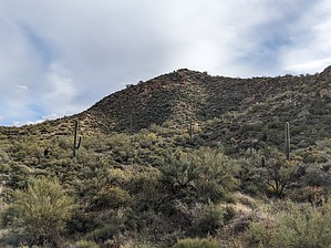
As red as the blood seeping from your extremities
by pseudalpine

 
Overview
A short hike to the 2769' peak (perhaps the second highest) on various topo maps. These hummocks are also sometimes referred to as Three Red Hills, which is a misnomer since there are more than three significant tors in this area.


A beautifully beguiling sweep bordered by Needle Canyon to the west and south, Marsh Valley to the east and La Barge Canyon to the north with Black, Bluff Spring and Malapais Mountains strikingly dominating these valley's peripheries.
remove free decal offer
History
Evidently, Adolph Ruth's skull was found near here in early December 1931 after his archaeological prospecting enchantment quest ended similarly as many other failed Superstition treasure hunters. Autopsies determined that he likely died of exposure after apparently ignoring an obvious and now very well-known warning, which is don't assume that you can withstand the oppressive heat of a Supes summer solstice. Reference Tom Kollenborn © 2022 Courtesy of the Apache Junction News and Apache Junction Public Library.

Approach & Hike
From any trailhead around the Superstitions, hike to Cavalry Trail #239. From the west junction with Boulder Canyon Trail #103, hike 1 mile east then head south off-trail up to 2769. If hiking from the junction with Dutchman Trail #104, hike up 1.25 mi before going south off-trail. The off-trail hike up to 2769 is nothing to fear.

Synopsis
This mini peak's crest has an interesting and contorted geology worth a short side trip from the Cavalry Trail #239 via the north slope, but cairns, ducks, or a summit register would be nonsensical on this relatively easy, minimally bushwhacky connector summit.

2024-01-07 pseudalpine


    Check out the Official Route and Triplogs.
    Leave No Trace and +Add a Triplog after your hike to support this local community.
    WARNING! Hiking and outdoor related sports can be dangerous. Be responsible and prepare for the trip. Study the area you are entering and plan accordingly. Dress for the current and unexpected weather changes. Take plenty of water. Never go alone. Make an itinerary with your plan(s), route(s), destination(s) and expected return time. Give your itinerary to trusted family and/or friends.

     Permit $$
    None


     Directions
    or
     Road
    Paved - Car Okay

    To First Water Trailhead
    From Mesa follow Highway 60 East to Idaho Road. Turn North onto Idaho Road which is SR88 and follow North 2.2 miles. SR88 bends right just past Scenic St. and Idaho continues North. Be sure to go right and stay on SR88. Follow SR88 5.2 miles to the signed turnoff for First Water Trailhead, this is FR-78. Turn right on to FR-78 and follow 2.6 miles to the end.

    This trailhead feature restrooms without running water. The large parking area fills up in season. When full utilize the Horse Lot 0.5 miles back.

    From PHX (I-10 & AZ-51) 43.1 mi - about 59 mins
    From TUC (Jct 1-10 & Grant) 136 mi - about 2 hours 16 mins
    From FLG (Jct I-17 & I-40) 187 mi - about 3 hours 3 mins
    page created by pseudalpine on Jan 07 2024 7:23 am
     90+° 8am - 6pm kills
    helpcorrectionissue

    end of page marker