username
X
password
register
for free!
help
 

Transmission Ridge - South Mountain, AZ

Guide 3 Triplogs  0 Topics
  1.5 of 5  
Fav
Wish
0
details
drive
no permit
forecast
route  
stats
photo
triplogs
topics
location
1 3 0
Statistics
tap row or icons for details
Difficulty 1 of 5
Route Finding 1 of 5
Distance One Way 0.74 miles
Trailhead Elevation 1,419 feet
Elevation Gain 506 feet
Accumulated Gain 506 feet
Avg Time One Way 1 hour
Kokopelli Seeds 2.43
 Backpack No
feature photo
Photos Viewed All MineFollowing
1  2024-01-08 pseudalpine
24  2023-12-29
Desert Classic to Gila Valley Lookout
LindaAnn
Author
author avatar Guides 59
Routes 1,100
Photos 1,191
Trips 1,290 map ( 9,859 miles )
Age Male Gender
Location Arizona
Historical Weather
Trailhead Forecast
Radar Map
Expand Map
Preferred Nov, Dec, Jan, Feb
Seasons   Autumn to Spring
Sun  6:05am - 6:48pm
Official Route
 
1 Alternative


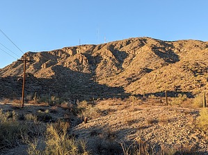
Electric Slide Boogie Sesh
by pseudalpine

Similarly to the Guadalupe Ridge - AKA Midlife Crisis / Scott, this is not an officially recognized South Mountain Park/Preserve trail, but it is definitely a trail that neighborhood hikers, dog walkers and runners use regularly. There aren't any do not enter or keep out revegetation area signs posted at the Desert Classic spur.


The route essentially follows mostly below the obvious transmission lines that provide power to some of the TV sites on Mount Suappoa. It's about a three-quarter mile uphill trek to where the trail peters-out on a prominent ridge, so a roundtrip jaunt from the DC junction would only be about a mile and a half total. Some of the Sonoran's arid desert plants are represented well on these sunny southern slopes of SoMo, most notably some charming Torote trees along the route.
remove free decal offer
The closest and easiest public access point is from the Desert Foothills Trailhead. From there, follow the Telegraph Pass Trail north less than a half mile to the Desert Classic, then southeast to the crossover junction at a major wash. I thought there was a mangled vehicle from a suicide somewhere in a drainage up near this trail's northern terminus, but I did not see it or spend time searching for it either. Perhaps the macabre scene has since been erased.

2024-01-10 pseudalpine


    Check out the Official Route and Triplogs.
    Leave No Trace and +Add a Triplog after your hike to support this local community.

    One-Way Notice
    This hike is listed as One-Way.

    When hiking several trails on a single "hike", log it with a generic name that describes the hike. Then link the trails traveled, check out the example.
    WARNING! Hiking and outdoor related sports can be dangerous. Be responsible and prepare for the trip. Study the area you are entering and plan accordingly. Dress for the current and unexpected weather changes. Take plenty of water. Never go alone. Make an itinerary with your plan(s), route(s), destination(s) and expected return time. Give your itinerary to trusted family and/or friends.

     Permit $$
    None


     Directions
    or
     Road
    Connector trail - Not Applicable

    To Telegraph Pass Trailhead
    From I-10 take Chandler Boulevard 4.8mi west to Desert Foothills Parkway. Turn right and follow 1.3mi. The parkway curves west. It's easy to find.

    Quicker: Alternate route: From I-10 and the Loop 202 take Pecos Road west, which is a westward extension of the 202. Go 5 miles to Desert Foothills Parkway. Take a right going north on DFP for 2.5 miles to the trailhead on the right side of the road.

    From PHX (I-10 & AZ-51) 19.4 mi - about 30 mins
    From TUC (Jct 1-10 & Grant) 102 mi - about 1 hour 36 mins
    From FLG (Jct I-17 & I-40) 163 mi - about 2 hours 37 mins
    page created by pseudalpine on Jan 10 2024 5:24 am
     90+° 8am - 6pm kills
    helpcorrectionissue

    end of page marker