Route Editor

| Guide | ♦ | 1 Triplog | 0 Topics |
details | drive | permit | forecast | route |
stats |
photos | triplog | topics | location |
| 43 | 1 | 0 |
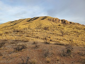
The Johnny Lyon Hills SOUTH High Point by Mike_W  Overview OverviewKeith Peak is named after the family that owns Keith Ranch and is at an elevation of 5,664 feet. It is in the Johnny Lyon Hills and is about 65 feet short of the high point of the range to the north. I suppose it could be considered the southern high point of the range. There is a mix of private property and AZ state trust lands beyond the unlocked gate near where you parked, which is only meant for foot access. You can hike Keith Peak by itself if you're looking for a shorter hike OR in conjunction with the Johnny Lyon Hills HP, which would make for a longer day. In my opinion, Keith Peak was a more enjoyable hike compared to the range high point because there were animal trails that went nearly all the way to the top and you won't need to deal with climbing through any messy brush or extremely rocky areas which are both found in abundance on the way to the high point. Hike Walk through the gate near the parking area and be sure to keep it closed using the chain/notch mechanism to secure the gate. At this gate, you should be able to see the peak which is the highest point you can see up ahead and to the right. Below the peak are some rocky cliffs which you'll hike around and over from the left/north side.
Once you start climbing, it quickly becomes an open Country hike and if there are any thorny bushes, you'll easily be able to go around them. I remember seeing a lot of dry grass, some scattered agave, some ocotillo, some smaller mesquite trees, some patches of shin dagger, a few rainbow cacti, etc. Keep going in the direction of the peak and zig-zag as needed, following cattle trails. It's probably better to stay out of the small washes which are often times messy and contain more thorny plants. When you get higher up, you will probably see a barbed wire fence. Follow the fence line south until you see the end of it, before some rocky cliffs to the south. From here, you will walk around the fence and up the hillside to get above these rocky cliffs. You should see some good animal trails in this area which will lead you up to a saddle-like area with some mesquite trees. From here, the summit is only another 700 feet or so to your east up a fairly steep grassy slope. You'll probably want to zig-zag on this final approach to get a better footing. I found some animal trails up on this slope which made the hiking pretty easy and enjoyable. At the summit, you will see a rock pile with a registry under it. Looking about 2 miles north/northwest you will see the Johnny Lyons Hills HP and the rocky ridge leading up to it. Looking to the west, in the distance, you should see the Rincons and Little Rincons. To hike down, go the same way until you get to the barbed wire fence. Follow the fence line for a few minutes and then looking to your left/west you should see a gentle ridgeline going down. You can either follow this ridgeline down which I did to add a little variety, or you can go back down the same way you came. If you take the alternate ridgeline, you'll start off going west and then eventually curve going northwest. The first mile of this is pretty easy and enjoyable hiking. Along the way, I found some flat areas with some trees where cattle obviously hung out. After you get to the bottom and cross over a few rolling hills, you'll need to decide the best way to get back to the dirt road. I ended up having to cross 2 canyons and weave through some brush along the way back to the dirt road. You may be able to avoid some of this brush by hiking north to get back to the road, however, it will be slightly longer going that way. Then, take the road back down to your starting point. When in doubt, you're welcome to just follow my route. Gate Policy: If a gate is closed upon arrival, leave it closed after you go through. If it is open, leave it open. Leaving a closed gate open may put cattle in danger. Closing an open gate may cut them off from water. Please be respectful, leave gates as found. The exception is signage on the gate directing you otherwise.
Check out the Official Route and Triplog. Leave No Trace and +Add a Triplog after your hike to support this local community. | ||||||||||||||||||||||||||||||||||||||||||||||||||||||||||||||||||||||||||||||||||||||||