Route Editor

| Guide | ♦ | 1 Triplog | 0 Topics |
details | drive | no permit | forecast | 🔥 route |
stats |
photos | triplog | topics | location |
| 0 | 1 | 0 |
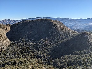
Best-Ever Peak, umm, Just Kidding! by pseudalpine  Overview OverviewThis broad cluster of three individual hilltops is at the eastern periphery of the Superstition Mountains and is split by the angling Pinal and Gila County line. The triple grouping is northeast and an ancillary area of Larry the Snail 4431. These distinct geographic features are separated by a minor limestone saddle highpoint (4242) with adjacent west and east cols. Hike At slightly over the half-mile point of the ascent to Larry the Snail, another faint cattle trail drops east to the western saddle of 4242, at which point any sign of this path disappears. The south side of 4242 is less vegetated than the north, so traversing around that side isn't too taxing. The eastern saddle of 4242 is more open because it appears to be where the cattle prefer to mingle amongst the grass under the shade of some large Juniper and Mesquite trees. From this saddle, one can ascend the southwestern slope for a few hundred more feet to reach the sweeping mountaintop.
There was every intention of looping through each of the three hilltops, but once at 4490, Dese and I had commiserated through enough Catclaw Acacia and Fairy Duster for the day and bailed, returning along the same approach route. The total hike, including both summits of Larry the Snail and the J K Mountain apogee, is about three and a quarter miles roundtrip from FR 287A. Check out the Official Route and Triplog. Leave No Trace and +Add a Triplog after your hike to support this local community. | ||||||||||||||||||||||||||||||||||||||||||||||||||||||||||||||||||||||||||||||||||||||||