Route Editor

| Guide | ♦ | 1 Triplog | 0 Topics |
details | drive | permit | forecast | 🔥 route |
stats |
photos | triplog | topics | location |
| 38 | 1 | 0 |
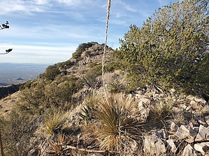
3rd highest prominent peak in Santa Ritas and few people heard of it! by Mike_W  Overview OverviewPeak 6311 in the Santa Ritas, which has an elevation of 6311 feet, involves 1.25 miles round trip of off-trail hiking and the rest of the hike is on well-maintained dirt roads. The off-trail section involves climbing up a grassy steep grade to a high saddle and hiking roughly 1/3 of a mile along a rocky ridgeline to a high point. There were a few thorny areas and it was easy to hike around these areas. This peak is only one of four peaks in the Santa Rita range with over 1,000 feet of prominence. Those 4 peaks are Mt. Wrightson, Mt Hopkins, this one, and Mt Fagan, in order from highest prominence to lowest. This hike is by far the easiest of the 4 peaks mentioned mainly because some good roads are going pretty close to it. Hike If you park at the bottom of FS 231, this is roughly a 6-mile roundtrip hike. If you continue driving on FS 231 you can reduce the distance and elevation change of this hike depending on how far you drive.
Walk the roads as indicated in the driving directions if necessary. Near the end of FS 4053 A, you will see a 5-foot-tall rock enclosure that was probably made by miners who were here. It's hard to tell what this was used for. Anyway, continue for a few hundred feet and you'll see a trail branching off from the road going west, up the side of the mountain. I found a stake here with a pink ribbon. Be careful in this area because there are a few mining holes. I saw a warning sign in front of one of them, so I would imagine all of the large holes have warning signs. From here, I followed various animal trails for roughly 1/4 mile to get to the saddle south of Peak 6311. Then, I continued northwest along the rocky ridgeline to the summit. The saddle is covered with a lot of shin daggers. The best way to deal with shin dagger is to avoid it completely! However, there are times when it covers an area so large that the only way to proceed is to hike over it. Step on it, rather than next to it to avoid getting sliced up. The last 800 feet of getting to the summit was a little slower because it was very rocky with some trees and brush to go around. At the peak, I looked in the most obvious spots for a registry but didn't find one. Luckily, I had a glass jar with me so I started a new registry and secured it under a few rocks. From the summit, I could see the rocky ridgeline continuing down to the northwest. Looking Northwest I could see the Helvetia mine which was closer than I expected. Looking to the North, in the distance I could see the Catalinas and the Rincons. Looking south I could see the snow-capped Mt Wrightson. Follow the same route back to where you parked. When I hiked down, I ended up hiking more toward the saddle west of Peak 5978 to cut down on the slope. Then, when I got near the canyon at the bottom, I found a very good animal trail that ran alongside the canyon and continued for a few hundred feet before disappearing. Then I found more human or animal trails which I followed and they led back to the same pink ribbon stake that I saw earlier. Once on the road, I just went back the same way to where I parked. Check out the Official Route and Triplog. Leave No Trace and +Add a Triplog after your hike to support this local community. | |||||||||||||||||||||||||||||||||||||||||||||||||||||||||||||||||||||||||||||||||||||||||||||||||||||