Route Editor

| Guide | ♦ | 1 Triplog | 0 Topics |
details | drive | no permit | forecast | route |
stats |
photos | triplog | topics | location |
| 18 | 1 | 0 |
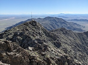
An Elephant Tree Never Forgets by pseudalpine  Overview OverviewIf one follows the official route, this hike will tally two peaks when linking this guide and Montezuma Peak 4354. It’s dubious Montezumas Head 2411 will ever have a published guide, so this doublet of the same summit compensates for this implausibility. Considering all the other labeled highpoints one will pass over, the track sums six peaks. The CCW loop includes: Montezumas Head 2411, Peak 2911, Peak 3092, BM 3051, Peak 2883 and MP 4354. And there are quite a few more I missed since they weren’t in the favored line of travel (a great reason to go back and explore some more). There’s a true ridgeline alternate route up there with several peaks lined up and others that could be done as side trips by faster, stronger, and younger hikers. Hike You'll be following roads for the first six miles, but don't fret, much of them could hardly be considered roads and the Sonoran Desert isn't too shabby through here tucked in between the the Whole Enchilada ridgeline and the Sierra Estrella. The road parallels the wilderness boundary generally bearing southeast. One will pass a road spur at 1.42 miles, which also tracks the boundary northeast onto the broad bajada benchmarked 1770. At 2.41 miles, there's a four-way junction, where one keeps going southeast. This could be an alternate start/end point for this hike. At 3.18 miles, you'll be hiking in a sandy arroyo for a quarter mile until exiting left onto an obscure road that enters the Gila River Indian Reservation and then comes and mostly goes. You'll be in open desert for a while now, generally heading east through a craggier landscape that is more interesting. You'll split the north side of the southern Estrella foothills until about 5.34 miles, where the Peak 1877 hillside is carved away near a dike and some culverts. You'll follow a much better road now, but briefly before heading left (northeast) back into open desert until reaching the base of Montezumas Head.
Synopsis This route isn't as much of a true ridgeline hike as the other two Sierra Estrella Torote Loops, but still a rewarding and challenging trek. Perhaps the least difficult of the three because it has more sections of relatively facile terrain. Check out the Official Route and Triplog. Leave No Trace and +Add a Triplog after your hike to support this local community. | ||||||||||||||||||||||||||||||||||||||||||||||||||||||||||||||||||||||||||||||||||||||||||||||||