username
X
password
register
for free!
help


Little Table Top 3097, AZ

Guide 1 Triplog  0 Topics
  2 of 5  
Fav
Wish
0
details
drive
no permit
forecast
route  
stats
photos
triplog
topics
location
0 1 0
Statistics
tap row or icons for details
Difficulty 1.5 of 5
Route Finding 1 of 5
Distance Round Trip 3.68 miles
Trailhead Elevation 2,294 feet
Elevation Gain 799 feet
Accumulated Gain 971 feet
Avg Time Round Trip 2.5 hours
Kokopelli Seeds 8.54
 Interest Off-Trail Hiking & Peak
 Backpack Possible - Not Popular
feature photo
Photos Viewed All MineFollowing
5  2024-03-06
Table Top Trifecta
pseudalpine
Author
author avatar Guides 59
Routes 1,100
Photos 1,191
Trips 1,290 map ( 9,859 miles )
Age Male Gender
Location Arizona
Historical Weather
Trailhead Forecast
Radar Map
Expand Map
Preferred Nov, Dec, Jan, Feb → 7 AM
Seasons   Autumn to Spring
Sun  6:06am - 6:48pm
Official Route
 
0 Alternative


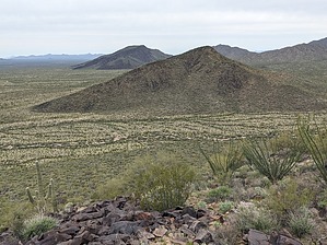
Diminutive Outlier
by pseudalpine

  
Overview
This out-and-back route starts within the Table Top Wilderness and tops out at the 3097 highpoint on Tohono O'odham Nation land. It's similar to the Black Mountain 3306 summit, but more compact and a tad easier (less mileage and AEG).


Hike
There's a road (not signed with a number) heading south from the Table Top Trail TH that you'll hike for less than a quarter mile before going off trail bearing southeast. The desert here is surprisingly open, meandering mainly through Creosote, Saguaro and Teddy-bear cholla.
remove free decal offer
After a mile of generally hiking southeast, you'll have to gap a barbed wire fence, which is the boundary between the Table Top Wilderness and Papago Reservation. There's one major wash crossing and then the steep climb up the northwest-facing slope begins in earnest. The summit is similarly black basalt boulders as the other mountaintops in this area. The official route returns via the same track as the approach.

Synopsis
Definitely small-scale and not quite as flat when compared to its parent peak, but still a worthy mountain. Overall, it's another good, elevated, and unobstructed perspective of Table Top Mountain, and the Sonoran Desert views east, south, and west.


2024-03-06 pseudalpine


    Check out the Official Route and Triplog.
    Leave No Trace and +Add a Triplog after your hike to support this local community.
    WARNING! Hiking and outdoor related sports can be dangerous. Be responsible and prepare for the trip. Study the area you are entering and plan accordingly. Dress for the current and unexpected weather changes. Take plenty of water. Never go alone. Make an itinerary with your plan(s), route(s), destination(s) and expected return time. Give your itinerary to trusted family and/or friends.

     Permit $$
    None


     Directions
    or
     Road
    High Clearance possible when dry

    To Table Top Trailhead
    From the junction of I-10 and I-8 near Casa Grande, proceed west on I-8 for 34 miles. Take Exit 144 and then go south on Vekol Road. After the pavement ends travel about 10 miles where you will come to an intersection. Bear to the left (east) and continue about 4 miles to the Table Top Trailhead parking area. There are also several vertical "Trail" signs with arrows to direct you.

    From PHX (I-10 & AZ-51) - 1 hr 48 min (74.5 miles)
    From TUC (Jct 1-10 & Grant) - 2 hr 10 min (107 miles)
    From FLG (Jct I-17 & I-40) - 3 hr 58 min (218 miles)
    page created by pseudalpine on Mar 06 2024 9:21 pm
     90+° 8am - 6pm kills
    helpcorrectionissue

    end of page marker