username
X
password
register
for free!
help


Black Mountain 3306 - Table Top Wilderness, AZ

Guide 1 Triplog  0 Topics
  2 of 5  
Fav
Wish
0
details
drive
no permit
forecast
route  
stats
photos
triplog
topics
location
0 1 0
Statistics
tap row or icons for details
Difficulty 1.5 of 5
Route Finding 2 of 5
Distance One Way 2.54 miles
Trailhead Elevation 2,116 feet
Elevation Gain 1,177 feet
Accumulated Gain 1,184 feet
Avg Time One Way 4 hours
Kokopelli Seeds 6.49
 Interest Off-Trail Hiking & Peak
 Backpack Possible - Not Popular
feature photo
Photos Viewed All MineFollowing
5  2024-03-06
Table Top Trifecta
pseudalpine
Author
author avatar Guides 59
Routes 1,100
Photos 1,191
Trips 1,290 map ( 9,859 miles )
Age Male Gender
Location Arizona
Historical Weather
Trailhead Forecast
Radar Map
Expand Map
Preferred Nov, Dec, Jan, Feb → 6 AM
Seasons   Autumn to Spring
Sun  6:06am - 6:48pm
Official Route
 
0 Alternative


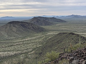
Black Bouldery Balderdash
by pseudalpine

  
Overview
A point-to-point (one-way) summit route that more than likely will be hiked as an approximately 7.5-mile lasso loop, considering that the Lava Flow Trail (Vekol) can be used in any number of ways, for a more efficient approach to / return from any of its three starting trailheads.


Hike
The most direct route is from the Lava Flow West TH, where one will follow the Vekol La HAZ (black official route) east. Busters Revenge splits off north (left) after a half mile. Stay on Vekol La HAZ, hiking east for 1.2 miles total, where you'll bear southeast (left), off-trail into the open desert, working your way up to Black Mountain's northwest basaltic slopes. It becomes a boulderdash acclivity, literally requiring hopping up thousands of black rocks that have been deposited over time with the occasional, white-stained perches from pooping Aves.
remove free decal offer
You'll perhaps pass over the 2543 rise and reach the summit after ascending 2.63 miles total. After your break, pretend you're an effusive and inviscid lava droplet and slowly descend the steep south ridge without wiping out. Eventually, you'll get to a saddle and then angle southeast into a wash that links into the Lava Flow Trail after about 3.72 miles total. From this point, it's an easy stroll west and north through some dramatic Sonoran Desert landscape, 3.84 miles back to the Lava Flow (West) TH.

Synopsis
Less bushwhacky and a better-than-expected mountain summit. Fighter jets will pass fairly high, directly above (usually going southeast) throughout the day and one can hear constant rumbles of them to the west over the Barry M Goldwater Air Force Range. There's ample evidence of migrant activity in many areas, both on and off trail.

2024-03-06 pseudalpine


    Check out the Official Route and Triplog.
    Leave No Trace and +Add a Triplog after your hike to support this local community.

    One-Way Notice
    This hike is listed as One-Way.

    When hiking several trails on a single "hike", log it with a generic name that describes the hike. Then link the trails traveled, check out the example.
    WARNING! Hiking and outdoor related sports can be dangerous. Be responsible and prepare for the trip. Study the area you are entering and plan accordingly. Dress for the current and unexpected weather changes. Take plenty of water. Never go alone. Make an itinerary with your plan(s), route(s), destination(s) and expected return time. Give your itinerary to trusted family and/or friends.

     Permit $$
    None


     Directions
    or
     Road
    High Clearance possible when dry

    To hike
    Lava Flow (West) is preferred, but possible from (South) or (North) trailheads also. Reference the Table Top Mountains Access Map included in either of the Lava Flow Trail (Vekol) or Table Top Trail guides.
    page created by pseudalpine on Mar 06 2024 8:10 pm
     90+° 8am - 6pm kills
    helpcorrectionissue

    end of page marker