 Route Editor

| Guide | ♦ | 3 Triplogs | 0 Topics |
details | drive | no permit | forecast | route |
stats |
photos | triplogs | topics | location |
| 0 | 3 | 0 |
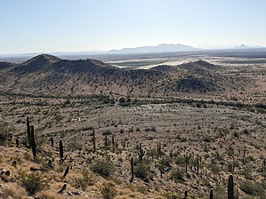
BYO Slingshot & Limes by pseudalpine  Overview OverviewThe West Butte Trail is one of six named trails in the Casa Grande Mountain Park. It's an interior trail, even though one may most easily access it from the unimproved Henness Road Trailhead at the southern side of the park. The official route begins at the E-2 EMS Marker (reference regional park map) and meanders generally north until terminating at a junction with the East Butte Trail. Hike The optimal way to complete this hike is to start at the Arica Road Trailhead (Paved - Car Okay) and follow the East Butte Trail to the aforementioned E-2 EMS Marker. From this switchback transition, one descends about 37 feet in 0.18 miles to near the Henness Road TH parking area. Continue north on the old road, quickly reaching one of the many Corona Satellite Calibration Targets that are located in this region. The route travels directly west for a bit and then northwest.
Synopsis An interior connector trail that can be integrated with some of the other park trails to form varying loops. There's only one brief section categorized by the City of Casa Grande as moderate and overall this trail is predominantly an uber-mellow Sonoran Desert stroll.
Check out the Official Route and Triplogs. Leave No Trace and +Add a Triplog after your hike to support this local community. One-Way Notice This hike is listed as One-Way. When hiking several trails on a single "hike", log it with a generic name that describes the hike. Then link the trails traveled, check out the example. | ||||||||||||||||||||||||||||||||||||||||||||||||||||||||||||||||||||||||||||||||||||||||||||


