username
X
password
register
for free!
help
 

Chain Cholla Forest Trail - CGMP, AZ

Guide 1 Triplog  0 Topics
  1 of 5  
Fav
Wish
0
details
drive
no permit
forecast
route  
stats
photos
triplog
topics
location
0 1 0
Statistics
tap row or icons for details
Difficulty 0.5 of 5
Route Finding 1 of 5
Distance One Way 0.13 miles
Trailhead Elevation 1,644 feet
Elevation Gain -29 feet
Avg Time One Way 5-10 min
Kokopelli Seeds 0.18
 Backpack No
feature photo
Photos Viewed All MineFollowing
5  2024-03-31
Big House Montañas
pseudalpine
Author
author avatar Guides 59
Routes 1,100
Photos 1,176
Trips 1,290 map ( 9,859 miles )
Age Male Gender
Location Arizona
Historical Weather
Trailhead Forecast
Radar Map
Expand Map
Preferred Nov, Dec, Jan, Feb → 7 AM
Seasons   Autumn to Spring
Sun  6:03am - 6:48pm
Official Route
 
0 Alternative


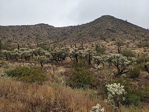
Suffering Succotash
by pseudalpine

Overview
This is a short, somewhat obscure, interior Casa Grande Mountain Park trail that precisely passes through a mini forest of jumping cacti. The official route starts at the northeast end at the quarter-mile mark of the apparently more traveled Saguaro Fork Trail.


Hike
This downhill track is orientated northeast to southwest and appears to not have much use. It is currently overgrown with wildflowers and weeds, and you'd probably not want to walk your dog and/or ride your bike on it because of the numerous prickly and irregular cholla segments that litter the ground.
remove free decal offer
Synopsis
This trail is likely to be completed as a supplementary option that would allow visitors to complete a loop with the adjacent Saguaro Fork Trail.

2024-03-31 pseudalpine
  • Map
    area related
    Map


Check out the Official Route and Triplog.
Leave No Trace and +Add a Triplog after your hike to support this local community.

One-Way Notice
This hike is listed as One-Way.

When hiking several trails on a single "hike", log it with a generic name that describes the hike. Then link the trails traveled, check out the example.
WARNING! Hiking and outdoor related sports can be dangerous. Be responsible and prepare for the trip. Study the area you are entering and plan accordingly. Dress for the current and unexpected weather changes. Take plenty of water. Never go alone. Make an itinerary with your plan(s), route(s), destination(s) and expected return time. Give your itinerary to trusted family and/or friends.

 Permit $$
None


 Directions
or
 Road
Connector trail - Not Applicable

To hike
Arica Road Trailhead: I-10 exit 200, south on Sunland Gin Road. Turn right at the truck entrance of the Love's Truck Stop and continue west to the trailhead at the end of Arica Road.
page created by pseudalpine on Mar 31 2024 7:58 pm
 90+° 8am - 6pm kills
helpcorrectionissue

end of page marker