Route Editor

| Guide | ♦ | 1 Triplog | 0 Topics |
details | drive | no permit | forecast | route |
stats |
photos | triplog | topics | location |
| 0 | 1 | 0 |
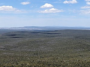
Shinrin-Yoku Stronghold by pseudalpine   Overview OverviewThis hike is a contorted lasso loop (CCW) that eventually gains the 6524' highpoint of Castle Peak in Grand - Canyon Parashant National Monument. It's a bit of a stretch and misnomer to associate the word peak to this mountain, as it's really only a broad grouping of hilltops elevated somewhat from the surrounding area. I suppose the lava bluffs that occasionally line the mountain horizontally were construed by some earlier cartographers as resembling that of castle walls. This summit is not depicted on the standard brochure map as are some of the other prominent landmarks in the monument, e.g., Mount Logan, Mount Trumbull, Mud Mountain, Poverty Mountain and Red Pockets Mountain (to name a few). Hike From your vehicle, head east up a series of red shale drainages to where it's easy to slightly limbo (depending on your height) below a worthless barbed wire fence. Continue ascending the steeper grade until a short lava cliff band can be scrambled up and through at 0.53 miles. The route tracks slightly south, but mostly east still to the top of the 6381' hilltop where one will have a view of Mount Dellenbaugh to the southeast. Descending northeast gains access to a less-vegetated saddle covered in red semi-cryptobiotic soil. After crossing this broad col, the low angle ridge on the south side of a brushier drainage allows relatively easy access to Castle Peak's multi-summited and broad top. The official route meanders the plateau, tracking along another set of lava cliffs at mile 3.69 and eventually passes through the highpoint. One may descend south, transverse a drainage, and ascend the brushier southern slope to rejoin the approach route. From there, it's about the same track back to where one parked.
This peak is named and labeled on topographic maps and seems that it would be great for mule deer hunting, but as a hike, it's really just a forest bath with only one good spot of limited views. One of my reasons for completing this hike was to tap into my inner thunder god and search for boring rock art sites and ruins, but I didn't have any luck attaining that goal. Perhaps others will if they decide to explore near here. Check out the Official Route and Triplog. Leave No Trace and +Add a Triplog after your hike to support this local community. | |||||||||||||||||||||||||||||||||||||||||||||||||||||||||||||||||||||||||||||||||||||