username
X
password
register
for free!
help
 This is likely a great time to hike this trail!  Check out "Preferred" months below, keep in mind this is an estimate. 
   🔥

Rustler Park to Barfoot LO, AZ

Guide 8 Triplogs  2 Topics
  4 of 5  
Fav
Wish
0
details
drive
permit
forecast
🔥
route  
stats
photos
triplogs
topics
location
182 8 2
Statistics
tap row or icons for details
Difficulty 1.5 of 5
Route Finding 1 of 5
Distance Round Trip 2.5 miles
Trailhead Elevation 8,460 feet
Elevation Gain 351 feet
Accumulated Gain 510 feet
Avg Time Round Trip 2 hours
Kokopelli Seeds 5.05
 Interest Peak
 Backpack Connecting Only
feature photo
Photos Viewed All MineFollowing
Inaugural Calculation on Button Tap!
10  2023-07-02 Jim
24  2023-07-02 Mike_W
50  2021-07-20
Arizona Fire Lookouts II
DixieFlyer
17  2020-09-13
Crest Trail - Barfoot Park to Fly's Peak
writelots
27  2020-06-17
Chiricahuas - South Flys and Snowshed
DixieFlyer
7  2018-10-26 Sredfield
25  2009-09-20 Vashti
7  2009-09-19 snakemarks
Page 1,  2
Author
author avatar Guides 17
Routes 297
Photos 1,808
Trips 276 map ( 1,708 miles )
Age Female Gender
Location Gilbert, AZ
Associated Areas
list map done
Tucson Region
Historical Weather
Trailhead Forecast
Radar Map
Expand Map
Preferred Aug, Sep, Jul, May
Seasons   Spring to Summer
Sun  5:54am - 6:38pm
Official Route
 
5 Alternative
 
Historic Fire Perimetersacres
🔥 2011 Horseshoe 2 Fire158.9 mi*
🔥 1994 Rattlesnake Fire50.4 mi*
🔥 View (All) - over Official Route 🔥
*perimeter length in miles


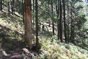
Lookout with a View worth Seeing!
by Vashti

 Likely In-Season! 
We hiked this segment of the crest trail while staying the weekend at Rustler Park Campground. The trail conveniently passes near the campground. Three adults, one 4-year old, one 3-year old, one 2-year old, and one 10-month old plus a Tibetan Mastiff, completed the hike. We were a motley crew! >:D The youngest two were in kid carriers, but the two older kids managed the hike quite well.


The official trailhead for this hike is actually before the campground and has a separate parking lot. However, there is a sign in the campground that says "trail" and leads you to the crest trail. From here, the posted sign lists the Barfoot Lookout at 1.5 miles away, leading to the right. We figured that was manageable for the kids. Flys Peak is to the left.
remove free decal offer
The trail continues up the ridge through a mixed forest. As you proceed further up the trail, the trees' breaks offer great views of the mountain range. We had beautiful weather for our hike. Wildflowers line the well defined and easily followed trail. The grade is not too strenuous but is up for most of the way. We reached a saddle with a sign listing Barfoot lookout as a quarter of a mile away. We continued up the trail. Near the top, the switchbacks are a bit more noticeable, but still not strenuous.

Barfoot lookout is on top of the ridge. As you trek up the last switchback out of the trees, you see the first building. The lookout comprises a cluster of pale yellow painted buildings, a gray pipe fence, and a nonfunctional light green painted pump. One building looks to be an outhouse, one a shed, and the other is the lookout building itself. All are locked. There is a sign that tells you that indeed you have reached Barfoot Lookout. The lookout house is beautiful. Perched on the bare rock, it is full of windows. A pipe fence extends out from the lookout house to offer some small protection from the dropoff. Recent maintenance has been done on the lookout site, as you can see an old screen door and some wood lying next to the lookout house. Peeking in the windows shows sign designating which canyon is which (since the purpose of the lookout house is for forest fire detection) and a plethora of paint cans as the inside of the lookout house is being redecorated. The views from the Lookout are enthralling and well worth the meager 1.5-mile trek up to the site. Seldom has a posted lookout point been so unique.

After some lunch and rest, our strange crew started down the mountain. The kids walking got very tired towards the end, but in general, I would recommend this as a family hike! :)

Note that the water system at Rustler Park Campground is no longer in service. Bring all the water you need.

2009-09-22 Vashti


    Check out the Official Route and Triplogs.
    Leave No Trace and +Add a Triplog after your hike to support this local community.
    WARNING! Hiking and outdoor related sports can be dangerous. Be responsible and prepare for the trip. Study the area you are entering and plan accordingly. Dress for the current and unexpected weather changes. Take plenty of water. Never go alone. Make an itinerary with your plan(s), route(s), destination(s) and expected return time. Give your itinerary to trusted family and/or friends.

     Permit $$
    Visit overview & permits.
    2024 - FAQ
    $8 per vehicle per day
    $10 per vehicle per week
    $40 per vehicle per year (valid for one year from the date of purchase)

    There are four specific day-use areas that require a Coronado Recreational Pass or a National Pass/America the Beautiful Pass.
    1) Sabino Canyon - located on the Santa Catalina Ranger District (520)749-8700
    2) Madera Canyon - located on the Nogales Ranger District (520)281-2296
    3) Cave Creek - located on the Douglas Ranger District (520)364-3468
    4) Mt. Lemmon at 11 day-use sites.

    2022 Catalina State Park
    Per vehicle (1-4 Adults): $7.00
    Individual/bicycle: $3.00

    2022 Sabino Canyon Tram is $15 extra. [ website ]

    Coronado Forest
    MVUMs are rarely necessary to review unless mentioned in the description or directions
    Coronado Motor Vehicle Use Maps (MVUMs)


     Directions
    or
     Road
    FR / Dirt Road / Gravel - Car Okay

    To Rustler Park CG Trailhead
    From Tucson, take I-10 east to Willcox. From Willcox, head south on AZ Highway 186 for 33 miles. Turn left (east) on AZ Highway 181 toward Chiricahua National Monument and drive 3 miles, then turn right (south) on FR 42 (Pinery Canyon Road). Continue up Pinery Canyon on FR 42 for 12 miles to the junction with FR 42D (Rustler Park Road), at Onion Saddle. Turn right and drive about 2.8 miles on FR 42D to the signed parking area for Rustler Park Trailhead on the left.

    Forest Roads 42 and 42D are gravel roads suitable for passenger vehicles. Open from April through November, they are not plowed and are usually closed following early or late season snowstorms. These roads are rough and dusty and may be muddy and slick after a rain.

    2009-08-11 Preston Sands: Sign at Rustler Park TH indicates trailhead parking is $5.00. It was not there last October.

    2009-09-22 Vashti: Campground fees are currently $10/night, trailhead parking is listed as $5/night on the sign.

    2021-10-06 JoelHazelton: Trailhead parking is $8.00

    From PHX (I-10 & AZ-51) 243 mi - about 4 hours 28 mins
    From TUC (Jct 1-10 & Grant) 134 mi - about 2 hours 53 mins
    From FLG (Jct I-17 & I-40) 387 mi - about 6 hours 34 mins
    page created by Vashti on Sep 22 2009 4:26 pm
     90+° 8am - 6pm kills
    helpcorrectionissue

    end of page marker