Route Editor

| Guide | ♦ | 1 Triplog | 0 Topics |
details | drive | no permit | forecast | 🔥 route |
stats |
photos | triplog | topics | location |
| 15 | 1 | 0 |
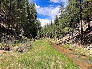
More Sequels Than Rambo by kingsnake   Overview OverviewIt wasn't until I got home from hiking Upper Miller Canyon that I realized my previous guide was only for Middle Miller Canyon, not the whole thing. Thus, you are hereby presented with part 3: Lower Miller Canyon. All three sections (~13 miles) could be tackled in a day, with a shuttle from FR 321 / FR 300 to FR 123A at the Arizona Trail above ECC. Hike From its intersection with FR 123, hike north on FR 9724V. (Stats reflect parking about 200 yards north of FR 123.) After ¼ mile, where FR 9723U splits right, split left through a gateless fence. Either follow FR 9724V to the rim of Miller Canyon, then turn northeast down a spur with slightly wider spaced contour lines, or do as I did: 50 yards after the split, turn right into the wide and shallow wash.
Once at the bottom of Miller Canyon, it is smooth sailing the next 5½ miles to ECC. 1⅓ miles into Lower Miller Canyon, there is a tight left bend in the canyon. A short saddle cuts across the bend. It would be a good place to avoid a flash flood — not that I saw signs of such. Just past that, on the east side of the canyon, is a possible bail point to FR 123. McCarty Draw is south at 3¼ miles. Just shy of 4 miles, a second bail point is on the south side of Miller Canyon. Once you reach ECC, turn east for ¼ mile to the AZT crossing. Make the 250 ft. climb up to the gate/trailhead. Either follow FR 123 to the "no motorized vehicles sign", and meet your shuttle there, or loop back to where you started via the AZT or FR 123. Gate Policy: If a gate is closed upon arrival, leave it closed after you go through. If it is open, leave it open. Leaving a closed gate open may put cattle in danger. Closing an open gate may cut them off from water. Please be respectful, leave gates as found. The exception is signage on the gate directing you otherwise. Check out the Official Route and Triplog. Leave No Trace and +Add a Triplog after your hike to support this local community. | ||||||||||||||||||||||||||||||||||||||||||||||||||||||||||||||||||||||||||||||||||||||||||||||||||||