username
X
password
register
for free!
help


Thash Kavid Loop Trail, AZ

Guide 13 Triplogs  0 Topics
  2.2 of 5  
Fav
Wish
0
details
drive
no permit
forecast
route  
stats
photos
triplogs
topics
location
0 13 0
Statistics
tap row or icons for details
Difficulty 0.5 of 5
Route Finding 1 of 5
Distance Lasso-Loop 2.11 miles
Trailhead Elevation 1,380 feet
Elevation Gain 115 feet
Accumulated Gain 151 feet
Avg Time Round Trip 45 minutes
Kokopelli Seeds 2.87
 Backpack No
feature photo
Photos Viewed All MineFollowing
7  2025-02-05
Gila Lookout from Warpaint
trekkin_gecko
7  2025-02-05
Corona Plus
LindaAnn
9  2025-02-05
Gila Lookout from Warpaint
chumley
4  2025-01-28
Corona Loop
johnlp
2  2024-07-10
Dobbins Lookout via Corona Loop
trekkin_gecko
3  2024-07-10
Dobbins Lookout via Corona Loop
johnlp
1  2024-06-07
Gila Lookout via Corona Loop
trekkin_gecko
1  2024-05-21
Corona Loop
pseudalpine
Author
author avatar Guides 59
Routes 1,100
Photos 1,176
Trips 1,290 map ( 9,859 miles )
Age Male Gender
Location Arizona
Historical Weather
Trailhead Forecast
Radar Map
Expand Map
Preferred Nov, Dec, Jan, Feb → 6 AM
Seasons   Autumn to Spring
Sun  6:04am - 6:50pm
Official Route
 
8 Alternative


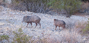
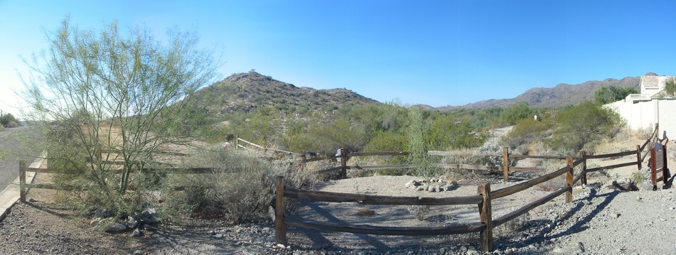
FKA Warpaint Loop Trail
by pseudalpine

 
Overview
Simply pronounced Tosh Ka-vad, which translates as Sun Shield in the OʼOdham language, the phrase represents a ring of light surrounding the sun that one may observe during a transcendent episode. It would be disingenuous to deny that one hasn't noticed the phenomenal eastern horizon predawn from this southeastern sector of the South Mountain Park and Preserve.


Hike
This Sonoran lowland, lasso loop is accessed from South Warpaint Drive between 5am-11pm and is plainly marked with burnt orange insignias on the numerous signposts along the route. The CCW order of trails for the official route is right at the first juncture (Thash Kavid), left at Desert Classic, and left again at Corona de Loma.
remove free decal offer
Synopsis
An easy loop hike that usually has a lot of mostly courteous mountain bike traffic because of its proximity to the Desert Classic Trail. The easy terrain and wide paths also attract dog walkers and runners from the nearby neighborhoods. Near the cooler holidays, grandparents are often seen accompanying their families here because of the trail's mellowness.

2024-05-21 pseudalpine


    Check out the Official Route and Triplogs.
    Leave No Trace and +Add a Triplog after your hike to support this local community.
    WARNING! Hiking and outdoor related sports can be dangerous. Be responsible and prepare for the trip. Study the area you are entering and plan accordingly. Dress for the current and unexpected weather changes. Take plenty of water. Never go alone. Make an itinerary with your plan(s), route(s), destination(s) and expected return time. Give your itinerary to trusted family and/or friends.

     Permit $$
    None


     Directions
    or
     Road
    Paved - Car Okay

    To Warpaint Trailhead
    Take the I-10 to exit 159 for Ray Road. Travel west on Ray Road about 1/4 mile until you reach the signaled intersection for 48th Street. Take 48th Street north until you reach the signaled intersection for E. Knox Road. Travel west on E. Knox Road until you reach Warpaint Drive. Travel north on Warpaint Drive about 1/4 mile. There is parking on the street. Trail head is on the west side of Warpaint Drive.

    From PHX (I-10 & AZ-51) 14.0 mi - about 21 mins
    From TUC (Jct 1-10 & Grant) 99.7 mi - about 1 hour 32 mins
    From FLG (Jct I-17 & I-40) 158 mi - about 2 hours 27 mins
    page created by pseudalpine on May 21 2024 4:39 pm
     90+° 8am - 6pm kills
    helpcorrectionissue

    end of page marker