Route Editor

| Guide | ♦ | 1 Triplog | 0 Topics |
details | drive | no permit | forecast | 🔥 route |
stats |
photos | triplog | topics | location |
| 41 | 1 | 0 |
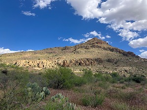
Easy intro to Wood Canyon peaks by John10s  Overview OverviewPeak 3820 is a scenic off-trail peak overlooking Wood Canyon. Although there are several higher peaks in the general vicinity, 3820 provides fantastic views of the surrounding area with a relatively easy, obstacle-free approach. More than half of the ~4.8-mile round-trip hike follows a jeep road, and the off-trail portion isn't particularly steep, giving the hike to the summit a high reward-to-effort ratio. Note The official route starts from a small pullout near a cattle guard along an unnamed jeep road at 33.247457, -111.109294. High clearance is recommended to reach this point, but 4x4 isn't necessary unless the road is especially wet. Depending on vehicle capability and road conditions, you can continue following this road and shorten the hike considerably by parking along the road ~1.4 miles into the official route, which will cut almost three miles of round-trip distance off the total. The driving directions linked here may provide a helpful reference for navigating the unmarked roads after turning off E. Arnett Road, but note that they continue past the point where you'd leave the road to approach the peak.
The guide for Wood Canyon - Peak 4054 includes a more detailed description of the early portion of the hike along the road, so refer to that for more specifics. Starting from the cattle guard, follow the road as it curves to the south. A little less than a half mile in, as the road turns to the east, you'll pass barbed wire and a stacked-rock fences on the left side of the road. It soon curves to the south again, opening up wider views of the impressive scenery around Wood Canyon, notable for the yellowish rock and interesting geology, including many small arches and caves/alcoves in the area. Peak 3820 becomes visible early in the hike, standing prominently on the east side of the road up ahead. A little over a mile in, you'll pass a water tank on the right side of the road, then a fairly large cave on the opposite side a little farther south. The official route leaves the road at ~1.4 miles to start approaching Peak 3820, but the north/northeast sides of the mountain are flat enough to offer plenty of options to reach the top; it's a trade-off between taking a more direct but steeper and brushier approach versus a longer but flatter route up a ridgeline that extends northeast from the high point. The official route splits the difference and takes a moderately steep approach, but you can make it more or less difficult depending on how closely you follow the route. You won't encounter any major obstacles on the way up, but depending on the time of year and dryness, the grasses can get tall and thick in many places and may leave your footwear covered in foxtails. There's also a surprisingly sturdy barbed wire fence partway up the mountainside that you'll need to cross if you're following the posted route, though you can avoid it by taking a more direct line toward the peak. The fence is tall enough that it's difficult to step over and has low barbs that make crawling under equally difficult, so you may have to follow it until you find some rocks to help step up and over. Past the fence, continue up to the ridge, and follow it past some rock outcroppings and over to the summit. From 3820, you're overlooking Wood Canyon and the continuation of the road that you followed on the way in. As you look north from the rocky summit, Picketpost Mountain is a major landmark, with the Superstitions beyond. The town of Superior and the Apache Leap cliffs are visible to the northeast, and looking south, you'll have nice views of Peak 4054 and the butte containing Tower Arch, both of which are good options if you're looking for a longer outing and want to extend the hike. Further south, you can see into the White Canyon Wilderness, including the distinctive shape of Battle Axe Butte. When you're ready to leave the peak, you can follow the same route back to the parking area or consider further exploration in the beautiful area around Wood Canyon. Check out the Official Route and Triplog. Leave No Trace and +Add a Triplog after your hike to support this local community. | |||||||||||||||||||||||||||||||||||||||||||||||||||||||||||||||||||||||||||||||||||||||||||