 Route Editor

| Guide | ♦ | 1 Triplog | 0 Topics |
details | drive | no permit | forecast | route |
stats |
photos | triplog | topics | location |
| 0 | 1 | 0 |
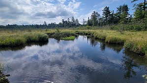
unique landscape by The_Eagle  The trail starts at the Swamp Line Trailhead and quickly immerses you in the park’s dense woods. You’ll walk through a variety of trees, including towering White Pines and hardwoods, and see the lush greenery of the forest floor. As you hike, you’ll cross over small streams and through marshy areas, which give the trail its name. The terrain can be uneven and muddy, so be prepared for a bit of a challenge.
This hike gives you access to the Sturgeon Bay Trail (This trail's termination point), Lindsey Trail, and also is a section of the North Country Trail. Check out the Official Route and Triplog. Leave No Trace and +Add a Triplog after your hike to support this local community. One-Way Notice This hike is listed as One-Way. When hiking several trails on a single "hike", log it with a generic name that describes the hike. Then link the trails traveled, check out the example. | |||||||||||||||||||||||||||||||||||||||||||||||||||||||||||||||||||||||||||||||


