Route Editor

| Guide | ♦ | 3 Triplogs | 0 Topics |
details | drive | no permit | forecast | route |
stats |
photos | triplogs | topics | location |
| 38 | 3 | 0 |
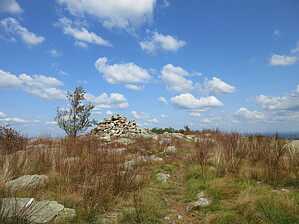
Not the last one, probably by Jim The Garvey Springs Trail is marked with orange blazes and leaves from the south side of the Old Mine Rd just east of the creek crossing next to the Douglas Parking area. I saw no signs marked for the trailhead, but an informational marquee of sorts near the road can help in locating the parking lot. There is a picnic area behind the parking lot.
Continue to follow the orange blazes to the ridge. It will briefly follow the same path as a trail marked with green blazes. On the ridge, white blazes for the Appalachian Trail are encountered. At the trail junction, there is a sign for the Garvey Springs Trail attached to a tree. This may be useful for descent. However, the sign faces the opposite direction you will be traveling when returning, so you need to pay attention. There are views of a lake in this area, as well. Follow the Appalachian Trail the remainder of the way to the summit of Mount Mohican. Most of the time you will hike through fairly dense and scrubby hardwoods. However, views open up as you near the summit. There will be a creek crossing, as well as a power line right-of-way. The summit is marked with a large cairn or rock pile, similar to Rincon Peak, in Arizona. Views here are very good and are kept open by pruning of vegetation by locals. Check out the Official Route and Triplogs. Leave No Trace and +Add a Triplog after your hike to support this local community. | |||||||||||||||||||||||||||||||||||||||||||||||||||||||||||||||||||||||||||||||||||||||||||||