Route Editor

| Guide | ♦ | 1 Triplog | 0 Topics |
details | drive | permit | forecast | route |
stats |
photos | triplog | topics | location |
| 64 | 1 | 0 |
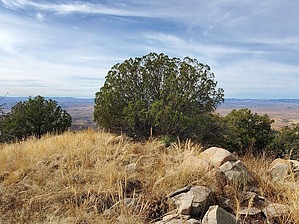
Gobble Gobble!! by Mike_W  Overview OverviewGuajalote Peak, at an elevation of 6,490 feet, is in the southern Patagonia Mountains. Roughly 7 miles of the hike involves walking on a 4x4 mining road which has a mix of flat, some gradual slopes, and some steep slopes. The remaining 2 miles (round trip) involve an open country hike up a ridgeline that involves going around a few obstacles like rocks, oak trees, juniper trees, and minimal brush. At the top, you'll have views of some other peaks in Patagonias and Santa Ritas. To the north, it will be possible to see Mt Wrightson and Mt Hopkins. To the south, you will see Veteran's Peak, and to the southwest, you'll be able to see the border wall and into Mexico. Along the way to Guajalote Peak, you'll have an option to also summit Red Hill, which is about halfway up, very close to the road. Hike From the parking area, walk east until you get to FSR 4695 which will be on your left. Climb up the road and within about 200 feet you should see a water tank, a trough, probably for cattle, and a cattle guard beyond that. I suppose the cows know where the water is and they have to climb the correct road to get to it. Continue walking across the cattle guard and continue along the road. After climbing the initial hill, you'll have roughly 0.9 miles of downhill on a gradual slope. After you've hiked about 0.5 miles you should get a view of Red Hill for the first time, which is to the north. It's hard to miss because there is a lot of reddish-colored rock near the summit. After the downhill section, the road crosses a wash and then climbs up. There are some switchbacks and turns and at just over 2 miles you should arrive at the saddle northwest of Red Hill.
On the climb down, I found a slightly better route and I saw 1 or 2 cairns. When I got back down to the saddle, I continued to Guajalote Peak. Note: The one-way distance from where I parked to Red Hill was 2.2 miles. If you hiked Red Hill and nothing else, your round trip should be something like 4.4 miles. There was about 820 feet of elevation change between where I parked and the Red Hill summit. From the saddle northwest of Red Hill, it's about 2.25 more miles to get to the summit of Guajalote Peak. From the saddle, continue on the road leading up. The elevation at the saddle is 5670 feet and Guajalote peak is at 6490 feet, so it's roughly only 800 feet of gain. Short after the saddle going up there are a few steep sections of road for about the next 1,000 feet. You'll see a rocky high point that you'll pass to the left side of. Then, the road flattens out for a while. At roughly 1.1 miles past the Red Hill saddle you'll see a gate with a sign that reads: Private Property No Trespassing By Off-Road Vehicles No Outlet This implies that the owner allows hikers and foot traffic to pass by. THANK YOU to the owners for allowing this! I walked around the gate, but I soon realized that wasn't necessary. There's another road leading to the right of the gate which can be taken also because the ridgeline going to Guajalote is further to the north, while the private property is to the west. I'm not sure where the actual border of the private property is, but you'll be basically going around most of the private property by taking the road going north. At roughly 3.6 miles, at this location 31.413282, -110.742357, there is a road leading west. This road is marked FSR 4697. Follow this road and you will see that it fades out after a few hundred feet. From here, you'll need to hike north and then west to get onto the middle of one of the ridgelines. From this point, I believe it's just under 1 mile to the summit. I followed the ridgeline up and only saw a few cairns in a few tricky areas. There were some steep areas but it seemed possible to zig-zag and walk around some of these steep areas. At times I was walking in what looked like a small gulch area and there were some larger rock slabs at one point. There were areas with 2-3 foot grass that I had to walk through. Be careful of any loose rocks mixed in with the grass. I just took my time and eventually, I was near the summit. I walked to all 3 high points sort of by accident. The actual high point was furthest to the west. At the summit, I found a registry under a rock pile. I also found 2 US survey markers with arrows pointing to the high point but didn't see the official US survey marker. By the way, the US survey marker, which was placed in 1936, displays a name of Guajolote, rather than Guajalote, which translates to turkey. No, I didn't see any turkeys all day, but they may be in the area. Perhaps Guajolote is the official name of this peak, even though the topo map shows Guajalote. From the summit, there were some nice views looking west, and looking north I could see some of the high points in the Patagonias, and north of that I could see the Santa Rita, especially the 2 high points - Mt Wrightson and Mt Hopkins. I followed the ridgeline down generally the same way I went up and found some of the same cairns on the way down but didn't see any other cairns along the ridgeline. Eventually, I walked onto the road and from there I just followed the road down to the bottom. Aside from the distance, it was a pleasant and peaceful hike. I didn't see a single person the entire day! Gate Policy: If a gate is closed upon arrival, leave it closed after you go through. If it is open, leave it open. Leaving a closed gate open may put cattle in danger. Closing an open gate may cut them off from water. Please be respectful, leave gates as found. The exception is signage on the gate directing you otherwise. Check out the Official Route and Triplog. Leave No Trace and +Add a Triplog after your hike to support this local community. | ||||||||||||||||||||||||||||||||||||||||||||||||||||||||||||||||||||||||||||||||||||||||||||