Route Editor

| Guide | ♦ | 1 Triplog | 0 Topics |
details | drive | no permit | forecast | route |
stats |
photos | triplog | topics | location |
| 15 | 1 | 0 |
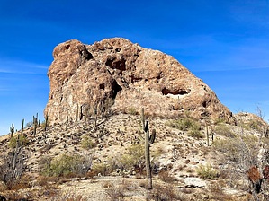
It's all over but the shootin' by kingsnake  If you drive to the trailhead via Sun Valley Parkway, as you pass through the retirement community, look south. Through a gap in the foothills: That free-standing butte is Elephant Rock. (It’s not visible from the trailhead / gate.) If you drive to the trailhead via Sun Valley Parkway, as you pass through the retirement community, look south. Through a gap in the foothills: That free-standing butte is Elephant Rock. (It’s not visible from the trailhead / gate.)How far you hike to Elephant Rock is up to you. There are two unnumbered jeep trails: The northern one is car-drivable for 2.9 miles to a triangle intersection. The southern one is SUV-able for 2.4 miles to a loop end. Proceeding past either point would require 4wd for deep, sandy, washes. Hiking either route is mild, with a slight climb as you head east towards the White Tanks.
Elephant Rock itself resembles White Rock 3012 above Telegraph Canyon: Smaller in circumference, but taller walls. Sheer walls — except on its north side. There is a 0.4-mile foot trail around Elephant Rock. The west approach is very steep (30%?) & slippery; east, much less so. At the saddle between Elephant Rock and its much smaller twin, I found a faint use trail in the rock, leading up a chute to the summit. (Marked Chute #1 on the GPS route.) It is a similar angle to Vulture Peak, but not quite as steep, or high, but also without obvious foot/hand holds. The rock is solid, not crumbly. If you fall, you are going to the bottom. I also spotted a possible route up the west face. Any other approach would require climbing gear. Hard to imagine this could be virgin rock climbing territory, but I could not find any routes online. Gate Policy: If a gate is closed upon arrival, leave it closed after you go through. If it is open, leave it open. Leaving a closed gate open may put cattle in danger. Closing an open gate may cut them off from water. Please be respectful, leave gates as found. The exception is signage on the gate directing you otherwise. Check out the Official Route and Triplog. Leave No Trace and +Add a Triplog after your hike to support this local community. | |||||||||||||||||||||||||||||||||||||||||||||||||||||||||||||||||||||||||||||||||||||