username
X
password
register
for free!
help


Golden Dome 3185, AZ

Guide 5 Triplogs  0 Topics
  4 of 5  
Fav
Wish
0
details
drive
no permit
forecast
route  
stats
photos
triplogs
topics
location
8 5 0
Statistics
tap row or icons for details
Difficulty 2.5 of 5
Route Finding 2 of 5
Distance Round Trip 1.44 miles
Trailhead Elevation 2,717 feet
Elevation Gain 475 feet
Accumulated Gain 654 feet
Avg Time Round Trip 1.5 hours
Kokopelli Seeds 4.71
 Interest Peak
 Backpack Possible - Not Popular
unreported if dogs are allowed
editedit > ops > dogs to adjust
feature photo
Photos Viewed All MineFollowing
Will recalculate on button tap!
27  2025-04-05
Golden Arches
chumley
43  2025-04-05
Golden Arches
John10s
8  2025-01-15
Goldfield Trifecta
pseudalpine
14  2023-02-04
Golden Dome
trekkin_gecko
12  2019-01-12
Golden Dome
chumley
Author
author avatar Guides 59
Routes 1,100
Photos 1,176
Trips 1,290 map ( 9,859 miles )
Age Male Gender
Location Arizona
Historical Weather
Trailhead Forecast
Radar Map
Expand Map
Preferred Nov, Dec, Jan, Feb → 7 AM
Seasons   Autumn to Spring
Sun  6:02am - 6:48pm
Official Route
 
2 Alternative


remove free decal offer
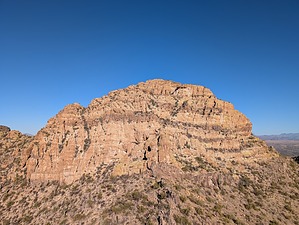
Tuffaceous Aureate Crown
by pseudalpine

 
Overview
A northerly located summit that distinguishes itself from the other peaks in the area because of its yellow hue with narrower dark striations. It definitely catches the eye and is about as remote a golden dome as possible.


Hike
Find a way to the Pedestal Arch via Cottonwood Wash to the south or one of the trailheads to the east, e.g. Triple Arch TH. From the broad saddle north of this small arch, ascend west and eventually traverse the ridges northwest. The southwestern aspects seemed less brushy than the northeast. Once at the final saddle before the peak, one may climb (cl.3) the direct east side official route or descend slightly left, traversing the base to access the easier southwest ridge scramble.

2025-01-22 pseudalpine


    Check out the Official Route and Triplogs.
    Leave No Trace and +Add a Triplog after your hike to support this local community.
    WARNING! Hiking and outdoor related sports can be dangerous. Be responsible and prepare for the trip. Study the area you are entering and plan accordingly. Dress for the current and unexpected weather changes. Take plenty of water. Never go alone. Make an itinerary with your plan(s), route(s), destination(s) and expected return time. Give your itinerary to trusted family and/or friends.

     Permit $$
    None


     Directions
    or
     Road
    Connector trail - Not Applicable

    To hike
    Connector route approached via the saddle located north of the Pedestal Arch.
    page created by pseudalpine on Jan 22 2025 6:34 am
     90+° 8am - 6pm kills
    helpcorrectionissue

    end of page marker