 Route Editor

| Guide | ♦ | 2 Triplogs | 0 Topics |
details | drive | no permit | forecast | route |
stats |
photos | triplogs | topics | location |
| 0 | 2 | 0 |
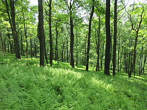
Go further for the view by Jim  The Farview is relatively wide and well-maintained, with a gentle grade. The forest is very lush and green in season, but you will have insects like mosquitoes if it has been wet. There is no great destination for the trail itself. It can be a nice short hike or longer if you connect to other trails. I recommend a longer hike with these connecting trails, as you won't see too many people, if you see anyone, and it is much quieter once about 1 mile from I-80 and the trailhead.
Check out the Official Route and Triplogs. Leave No Trace and +Add a Triplog after your hike to support this local community. One-Way Notice This hike is listed as One-Way. When hiking several trails on a single "hike", log it with a generic name that describes the hike. Then link the trails traveled, check out the example. | |||||||||||||||||||||||||||||||||||||||||||||||||||||||||||||||||||||||||||||||||||||||||||||


