 Route Editor

| Guide | ♦ | 7 Triplogs | 2 Topics |
details | drive | permit | forecast | 🔥 route |
stats |
photos | triplogs | topics | location |
| 51 | 7 | 2 |
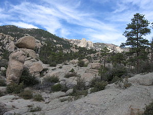
Lemmon Drop by sirena  Overview OverviewThis tour of the Catalinas starts at the top of Mount Lemmon and winds its way through numerous vegetative zones as you lose 7100ft of elevation, hike a part of the Arizona Trail, pass a famous swimming hole, and end with an enjoyable tram ride back to your car. I hiked this in an arid year, and there was still plenty of water available on the route. Shuttle To do this hike, you will need to put a car at the Sabino Canyon parking lot (see Fees/Permits below). Then drive up the mountain and enjoy the transition from saguaros to pines. You will see these same transitions on the way down the mountain.
While this hike is mostly downhill, it is steep at times and tough on the knees, so don't go into this thinking that it will be easy. Also, the time of year is essential for this hike. Spring and fall are best, but spring snowmelt may make creek crossings more difficult in spots. Make sure to check the temps at the top and the bottom before you go. Hike Above the Ski Valley, the uppermost parking lot is where this hike starts on Mount Lemmon Trail #5. Many of these hikes already have great descriptions here, so I will mostly be outlining the route. Take the Mount Lemmon Trail (an old roadbed) 0.4 miles to the junction with the Lemmon Rock Trail #12. Take a trip to the Lemmon Rock Lookout for expansive views of the whole valley and then head back to the Lemmon Rock Trail, which will lose 2000 feet of elevation in just 2 miles. The views of Rappel Rock, the Wilderness of Rock, and the Catalinas' front range are excellent and farther reaches such as Mount Wrightson and Baboquivari. The descent is steep to the Wilderness of Rock trail, but it is well graded with switchbacks. At the junction with the Wilderness of Rock trail, go right. (A left would take you to Marshall Saddle, east toward Summerhaven.) Welcome to the Wilderness of Rock. You are now on the Arizona Trail. The trail undulates for 2.3 miles between fantastic rock formations and in and out of creekbeds. There are great places to camp on this part of the trail. In Nov. '09, which was a very dry time, there were numerous waterholes. Some looked tastier than others. In wet years, I have seen this trail with running water in most of the creek crossings. There is a bit of up and down on this trail, but the views make it worthwhile. Besides, this hike is mostly downhill anyway. The junction to the Mount Lemmon Trail #5 is after a climb to a saddle. Another option is to take the Mount Lemmon Trail 3.5 miles from the trailhead down to this point, but my route adds only 1.2 miles and includes the Wilderness of Rock, one of my favorites. Take a left onto the Mount Lemmon Trail, which climbs for a little and then contours before descending steeply 1.9 miles to Romero Pass. This part was brushy but very well cairned. Great views of Picacho Peak, Cathedral Peak, Mt. Kimball, Table Mountain, and even tiny little Sombrero Peak are way down in the valley. At the junction with the Romero Canyon Trail #8 and the West Fork Trail #24, take a left onto the West Fork Trail. (a right here would take you to Catalina State Park) You are now descending into the West Fork of Sabino Canyon, A wide swath of green that cuts between the Catalinas' front and back range. Great views to the east down the West Fork, with Rincon Peak and Mica Mountain in the distance. 1.8 miles from the junction with the Romero Trail is a junction with the Cathedral Rock Trail #26, about 8.5 miles away from where you started and 4500 feet lower. This junction is in a beautiful riparian habitat with large oaks for tree cover. Stay on the West Fork Trail. For the next several miles, the trail winds in and out of the creekbed, always marked with large cairns. This is one of the prettiest parts of the hike. The remoteness (almost) guarantees that few people will be encountered. Be aware that there is poison ivy on this part of the trail. There will be water in the creek in wet times, but this hike was almost all dry, with isolated, very mucky-looking ponds. Fortunately, 3.4 miles away from the Cathedral Rock Trail's junction is Hutch's Pool, an enormous swimming hole that is just a short way north of the trail at a prominent cairn. You can see the pool from above, and it is about 150 feet long. This is a great shady spot to camp or take a long break. At this point, you are about 12 miles from where you started. From here, it is 1.6 miles to the end of the West Fork Trail at its junction with the East Fork Trail #24A and the Sabino Canyon Trail #23. The junction is after a wide creek crossing. Here you part ways with the Arizona Trail, which follows the East Fork Trail toward Prison Camp. Take the Sabino Canyon Trail up the hill out of the wash and contour around the canyon. You can see back to the top of Mount Lemmon and Rappel Rock, where this hike started. After two miles, you reach the junction with the Phoneline Trail #27. You could walk the Phoneline back to the parking lot and add 4.5 miles onto this hike description if you wanted. Or you could do what I did; stay on the Sabino Canyon Trail down the switchbacks to the Sabino Canyon Tram stop #9 and ride the tram (see Fees/Permits below) back to the parking lot. Check out the Official Route and Triplogs. Note This is a moderately difficult hike. Leave No Trace and +Add a Triplog after your hike to support this local community. | ||||||||||||||||||||||||||||||||||||||||||||||||||||||||||||||||||||||||||||||||||||||||||||||||||||||||||||||||||||||||||||||||||||||||||||||||||||||||||||||||||||||||||||||||||||||||||||||||||||


