 Route Editor

| Guide | 0 Triplogs | 0 Topics |
details | drive | no permit | forecast | 🔥 route |
stats |
photos | triplogs | topics | location |
| 11 | 0 | 0 |
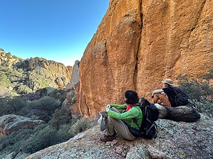
BYO Fish by GrangerGuy   Overview OverviewThe Fishhooks Wilderness is tucked up against the southwest side of the Gila Mountain Range, bordering the San Carlos Apache Indian Reservation north of Fort Thomas, AZ. There are no marked trails, but I located a route that appears to be regularly traveled and appears on some maps. The main road in from Fort Thomas passes through the Diamond Bar Ranch, which appears to be actively used from time to time. From the ranch, rough roads branch out in different directions along the edge of the wilderness, offering ample exploration opportunities. History The Fishhooks Wilderness was established in 1990 along with 38 other Arizona wilderness areas through H.R. 2570 sponsored by Morris K. Udall and ushered through the Senate by Dennis DeConcini. The "Fishhooks" name comes not from the barrel cactus of the same name, but rather the shape of Upper and Middle Fishhooks Canyons.
My original plan was to backpack up Upper Fishhook Canyon from Fishhook Well and do a loop including Middle and Upper Fishhook Canyon. This turned out to be difficult, and we turned back to the well as the navigation around a series of pour-overs became a challenge. At the last minute before the hike, I had spotted the unnamed trail on some maps, and we hiked a portion of that trail. This guide is for that trail. From the dispersed camping site just on the edge of the wilderness, follow an old road which can be seen on the 1989 USGS 7.5 Minute Gila Peak Topo map. Newer USGS maps do not show it, but you can find this map on the USGS collection of historical topo maps or on the HAZ Topo layer. It is now reduced to a single-track, but is clear to follow. The trail continues 1.5 miles, where it descends sharply to a spectacular viewpoint just above the Upper Fishhooks Canyon. This is an excellent turnaround point for a day hike into this wilderness. From the viewpoint, one could scramble down to the creek, which might be flowing after a rain. However, just before the descent to the viewpoint, the trail branches and continues up to the northern boundary of the wilderness, and then follows along the boundary to the southeast, eventually hooking around to the divide between the Upper and Middle Fishhooks Canyon. The HAZ adventurer can find this route on the OpenTopo layer, but it is mostly too faint to spot on aerial photographs. Check out the Official Route. Leave No Trace and +Add a Triplog after your hike to support this local community. One-Way Notice This hike is listed as One-Way. When hiking several trails on a single "hike", log it with a generic name that describes the hike. Then link the trails traveled, check out the example. | ||||||||||||||||||||||||||||||||||||||||||||||||||||||||||||||||||||||||||||||||||||||


