Note
2022-10-08 the desk at Sabino told me it was closed after cardiac gap because of a fire that happened two years ago. Check with the
rangers before you go here.
- robxxx
There are many reasons to visit this trail, but easy hiking is not one of them. Many hikers start along this trail which includes several miles of hard climbing because it leads to The Window, a 15' by 25' hole in a fin-like ridge that extends out from Window Peak on Pusch Ridge. For those who get to the top, this creation of gravity and frost frames an unforgettable view of Tucson and the mountains and valleys beyond. For those who choose to stop at points of interest that you can reach with less effort, there are plenty of rewards as well.
Esperero Canyon Trail starts in the Sabino Canyon Recreation Area, either from the Bear Canyon walkway just past the parking lot or pick it up from Sabino Road by Cactus Picnic Area or from Rattlesnake Trail opposite Shuttle Stop #1. If you come on any except the hottest days of summer, you'll be surprised at the amount of wildlife there is to see in the desert.
From its starting point, the trail passes through stands of wildly shaped saguaro cactus as it climbs up and over a low ridge into Bird Canyon. This serves as a warm-up for the lung-busting scramble up a particularly rocky section of the trail that goes up and over a second ridge and finally drops into Esperero Canyon. The trail then dodges its way up-canyon into Geronimo Meadow, crossing the creek on several occasions. Water can be found along this stretch during the wettest times of the year and sometimes at Mormon Springs, but don't count on it!
Above Geronimo Meadow, the trail climbs steeply up and out of the canyon to the ridge near Window Peak and finally to the Window itself. Take care when you get there. There is a sheer drop of over a hundred feet just outside that window.
Attractions: Desert canyon, access to the top of Pusch Ridge, spectacular views, and wildlife!
When hiking several trails on a single "hike", log it with a generic name that describes the hike. Then link the trails traveled, check out the example.
WARNING! Hiking and outdoor related sports can be dangerous. Be responsible and prepare for the trip. Study the area you are entering and plan accordingly. Dress for the current and unexpected weather changes. Take plenty of water. Never go alone. Make an itinerary with your plan(s), route(s), destination(s) and expected return time. Give your itinerary to trusted family and/or friends.
Four specific day-use areas require a Coronado Recreational Pass or a National Pass/America the Beautiful Pass.
1) Sabino Canyon - located on the Santa Catalina Ranger District (520)749-8700
2) Madera Canyon - located on the Nogales Ranger District (520)281-2296
3) Cave Creek - located on the Douglas Ranger District (520)364-3468
4) Mt. Lemmon at 11 day-use sites.
2025Catalina State Park
Per vehicle (1 person): $10.00
Per vehicle (2-4 people): $20.00
Individual/bicycle: $5.00
Coronado Forest MVUMs are rarely necessary to review unless mentioned in the description or directions Coronado Motor Vehicle Use Maps (MVUMs)
Directions
Road
Paved - Car Okay
To Sabino Canyon Recreation Trailhead From the intersection of Tanque Verde and Grant/Kolb Rd head northeast on Tanque Verde. Turn left at the second light on Sabino Canyon Rd. Go about 8 miles up Sabino Canyon Rd and you come to a four way stop with Sunrise. Go straight through the intersection and take the next right into the parking lot of Sabino Canyon Recreation Area. Signs marking the way start on North Kolb road.
This is the universal directions to Sabino Canyon Recreation Center. Hikes take off from all directions and some you might need to hike another trail to get to the start of your hike. Reference the hike summary for details.
From PHX (I-10 & AZ-51) 117 mi - about 1 hour 57 mins From TUC (Jct 1-10 & Grant) 14.1 mi - about 30 mins From FLG (Jct I-17 & I-40) 261 mi - about 4 hours 1 min
 Route Editor


 Note
Note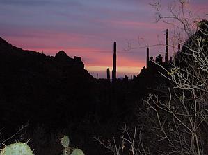


