 Route Editor

| Guide | ♦ | 16 Triplogs | 1 Topic |
details | drive | no permit | forecast | 🔥 route |
stats |
photos | triplogs | topic | location |
| 269 | 16 | 1 |
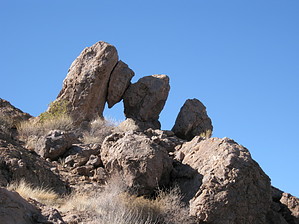
Plan Your Next Move by AZLOT69  Overview OverviewThis part of the Goldfields is loaded with interesting buttes two to four hundred feet off the desert floor offering great temptation to any peak bagger. Cool-weather is an invitation to bushwhack, scramble, scratch, climb and crawl to explore these formations many of which offer exclusive views. Checkmate first got my attention from Highway 88 at the needle vista turnout near milepost 204. It can be spotted in the distance thru the saddle to the west southwest at this location. With zoom photography, I began to doubt whether it was really an arch. This curiosity led to another adventure. The bottom line is that the purist would certainly argue that it's not a true arch but rather stacked rocks. When I looked at it up close I see different pieces, like pieces from a chessboard. The pieces from this ancient game remain in the endgame position of checkmate. Hike The hike starts off the Javelina trail one and one half miles northwest of the Javelina trailhead. As the Javelina Trail crosses a small wash headed northwest look up to the left and easily spot a large cave as well as checkmate arch above the cave to the right. Bushwhacking from here take the wash to the left and follow it thru some interesting areas thick with cholla and lichen-covered rock outcroppings on the right. These are worthy of checking out on their own. Continuing until you are almost directly beneath the cave start up the butte. There are several animal trails to follow. The vegetation is not too thick and can easily be avoided. Serpentine towards a ridge to the right and make your way up to the cave. It is very smooth rock on the inside and has a chimney-like opening to the sky above. While not as big as it appears from below it could certainly offer shelter. Checkmate is now out of sight but is above the cave to the right. Work your way up from the right side of the cave to checkmate. The views are awesome thru either side of the boulder-formed arch. Curiosity fulfilled, look up, we still have a peak to bag. Pick your moves carefully and mark them to remember for the descent. Its hands and feet for the last hundred feet to the top of the butte. 360-degree views make this a satisfying day. Return the way you came. Check out the Official Route and Triplogs. Leave No Trace and +Add a Triplog after your hike to support this local community. One-Way Notice This hike is listed as One-Way. When hiking several trails on a single "hike", log it with a generic name that describes the hike. Then link the trails traveled, check out the example. | ||||||||||||||||||||||||||||||||||||||||||||||||||||||||||||||||||||||||||||||||||||||||||||||||||||||||||||||||||||||||||||||||||||||||||||||||||||||||||||||||||||||||||||||||||||||||||||||||


