 Route Editor

| Guide | ♦ | 29 Triplogs | 0 Topics |
details | drive | no permit | forecast | 🔥 route |
stats |
photos | triplogs | topics | location |
| 413 | 29 | 0 |
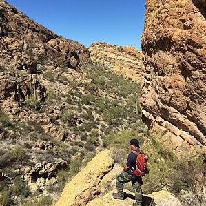
Roller coaster trail to a basin by markthurman53  Overview OverviewThis short 1.8-mile trail is a fun and scenic way to get to Willow Springs Basin and Tank. If you expect a pleasant walk through a narrow almost slot canyon, Stretches along a ridge, a little bit of AEG, and a pond of water at the end, then this trail has it. I have named this trail as such because it had no name that I could find. A portion of this trail is written up as the Little Chance Canyon Loop but it doesn’t describe the whole trail. The trail's southern terminus is at the Gold Eagles Nugget Trail (Javelina Willow Springs Crossover). The northern terminus is at the Willow Springs Canyon upper Trail just north of Willow Springs Basin Tank. This trail is in good shape and easy to follow with views of both Willow Springs Canyon to the east and Willow Springs Basin to the west. Halfway in along this trail is a 0.1 mile Spur (Willow Springs Basin Spur Route) that will take you to the Willow Springs Canyon Trail. At the tank, there is an 0.2-mile spur (Willow Spring Basin Tank Spur) that leads to the Willow Springs Tank Trail. Lots of potential for loop hikes. Hike This trail's southern terminus is at the Javelina Willow Springs Crossover Trail (Gold Eagles Nugget Trail). This trail exits north through a narrow almost slot canyon that appears to be called Little Chance Canyon. This is an interesting walk through a slot between two hills. The trail continues down this canyon for about 0.5 miles dropping about 250 feet before climbing up 120 feet to the ridge that separates Willow Springs Basin from Willow Springs Canyon. This is a really nice trail along this section with views to either side of the ridge. Just as you get done climbing this ridge it drops back down 120 feet onto the Willow Springs Canyon side of the ridge. The trail is a little steep here with loose rock. The trail crosses a creek and heads back up 120 feet to the top of the ridge again, another steep section. Where the trail crosses the creek there is an 0.1-mile spur trail (Willow Springs Basin Spur Trail) that leads to Willow Spring Canyon Trail. This is more of a route than a trail but it is marked with a cairn. From the top of the ridge, it is downhill for about 0.6 miles to Willow Springs Tank. From the tank, it is another 0.3 miles to Willow Spring Canyon Trail. Check out the Official Route and Triplogs. Leave No Trace and +Add a Triplog after your hike to support this local community. One-Way Notice This hike is listed as One-Way. When hiking several trails on a single "hike", log it with a generic name that describes the hike. Then link the trails traveled, check out the example. | |||||||||||||||||||||||||||||||||||||||||||||||||||||||||||||||||||||||||||||||||||||||||||||||||||||||||||||||||||||||||||||||||||||||||||||||||||||||||||||||||||||||||||||||||||||||||||||


