 Route Editor

| Guide | ♦ | 40 Triplogs | 0 Topics |
details | drive | no permit | forecast | 🔥 route |
stats |
photos | triplogs | topics | location |
| 77 | 40 | 0 |
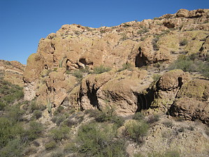
You Will Fly Over This Trail by AZLOT69  Overview OverviewThe Gold Eagles Nugget Trail is named for the mining claim it passes thru by the same name. The trail heads off in a westerly direction from the Little Chance Canyon Loop as a connector trail to the Javelina Mine Trail and the Golden Eye Mine Trail. This trail enables longer loops of the region starting or ending from the Willow Springs Trailhead. Hike The trailhead is located by taking the Little Chance Canyon Loop in a clockwise direction. Eight-tenths of a mile from the Willow Springs Trailhead, the Little Chance Canyon Loop Trail comes to a slick rock area where the trail crosses to the left side of the wash. In about a hundred yards there is a junction. It's easy to miss. You should see a cairn on your right here, stop look left for a large cairn. Go left here, this is your trailhead. There are several cairns thru this slick rock section guiding you off this ledge into the ravine ahead. Massive monoliths covered with lichen and accented with mature standing saguaro line the valley. The trail dips thru a wash then westerly towards the saddle ahead. Keep your eyes open for mining claim markers of interest. The trail crosses over to the right side of the wash as the grade starts towards the saddle. An open distant view of the Goldfields is yours at the saddle. There is a gate opening in a fence line that runs across the saddle. The trail now heads down into the valley ahead staying left of the ravine until it gets near the bottom where it crosses right. Soon you come to the unmarked Y with the Javelina Trail to your left and the Golden Eye Mine Trail to the right. Continue on your planned outing or return the way you came. Gate Policy: If a gate is closed upon arrival, leave it closed after you go through. If it is open, leave it open. Leaving a closed gate open may put cattle in danger. Closing an open gate may cut them off from water. Please be respectful, leave gates as found. The exception is signage on the gate directing you otherwise. Check out the Official Route and Triplogs. Leave No Trace and +Add a Triplog after your hike to support this local community. One-Way Notice This hike is listed as One-Way. When hiking several trails on a single "hike", log it with a generic name that describes the hike. Then link the trails traveled, check out the example. | |||||||||||||||||||||||||||||||||||||||||||||||||||||||||||||||||||||||||||||||||||||||||||||||||||||||||||||||||||||||||||||||||||||||||||||||||||||||||||||||||||||||||||||||||||||||||||||||||


