Route Editor

| Guide | ♦ | 85 Triplogs | 1 Topic |
details | drive | permit | forecast | 🔥 route |
stats |
photos | triplogs | topic | location |
| 1.4k | 85 | 1 |
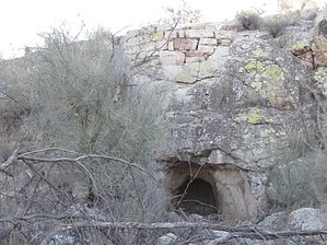
Shake And Bake by AZLOT69  Overview OverviewThis moderate-length loop hike offers plenty of perks. Described in a Clockwise direction, the hike begins and ends alongside the Salt River which generally has water flowing year-round which in itself is unusual in Arizona. This reliable source of water hosts a variety of waterfowl including ducks, Egrets, and Great Blue Heron. Passing by the cliffs of Blue Point may have you spotting a Bald Eagle. These cliffs host mating pairs every year and the area is generally posted during mating season. The trail shares a section with the Heber-Reno Sheep Driveway and passes by the Goldfield Ovens. You can expect to see Wild Horses on this trip. Splendid mature Sonoran flora line the trail. Entering the boulders area the trail follows a high ridgeline with views in all directions including Four Peaks, Stewart Mountain, Fountain Hills, and Saguaro Lake before dipping into Horse Thief Wash as the trail rejoins the Salt River for the final stretch. History While I was unable to locate any specific historical information about the Goldfield Ovens, my research uncovered a remarkable resemblance in size and construction to other ovens built by pioneers in the 1800s and early 1900s. With the additional evidence of limestone all around the immediate location, I concluded that this was a Limestone Kiln. These ovens were generally built into the side of a hill fashioned after the beehive design of coke ovens. Producing Quicklime was the object and most likely was used for making mortar, and bricks for building but had other uses such as removing hair from hides in leather making, and medicine.
A Tonto Day Pass (check Fees/Permit below for more info) is required to park at the Blue Point Recreation Site marking the trailhead for this hike. The trail starts behind the restrooms at the far north end of the parking lot. Join the trail by going left and pass thru the mesquite-filled area. This brings you to the north bank of the Salt River. Fishermen are often seen along the bank of the river which is lined with cattail and reeds. The trail hugs the cliff face of Blue Point for the first half-mile. There is ample evidence of rockslides here from the brittle rock face. Look up often as you quietly pass thru this area watching for Bald Eagles. Their nest sites are often given away by whitewashed rocks from bird scat. The trail descends into a wash at the one-half mile. This wash is part of the Heber-Reno Sheep Driveway which was established in 1890. To the left is Salt River beachfront land. This is where the sheep cross the Salt River on their way to winter feeding areas in the valley. Take the wash to the right or north. The cliff-lined wash is sandy. Almost immediately you may notice large amounts of scat that appear to be from deer. Sheep scat is very similar and hundreds pass this way twice a year. About one-third of a mile up the wash watch for a monster Saguaro. At three-quarters of a mile up the wash, it gets wider with golden cliffs on the left. Watch right for white limestone rock. Piles of loose white limestone indicate the location of the oven in the rock face. After the oven continues up the wash another 200 yards. Another wash joins in from the right. Stay in the main wash headed north. The wash narrows back down now and the walls lining it grow. The wash now curves right and Stewart Mountain appears dead ahead. The wash is continually gaining elevation as you move toward the high point of the trail. Rock outcroppings and boulders now make for an interesting landscape. Mature plants abound with some of the largest Ocotillos I have seen. When you come to an unmarked intersection bear right. This is at about the 3.5-mile point. The trail hits a high here as it mounts a ridgeline for a half-mile of incredible views in all directions. The trail descends into Horse Thief Wash. Go left in the wash and then bear right at further junctions. A short and interesting slot area has the trail join with the Stewart Mountain Dam Petroglyph Trail. Continue straight and take the culvert under the Bush Highway. When you come to the old alignment of the Bush Highway bear right. A tunnel of Salt Cedar and a hill will bring you up to the Water Users Recreation Site. Walk across the parking area all the way to the west where the trail picks up again behind the restroom next to a road closed sign. The trail crosses two washes then watch for a junction to bear right. The trail now passes thru the fence line to cross to the north side of the Bush Highway. The trail passes thru some additional old-growth saguaros in this section which has nonstop scenic views of the Goldfields on both sides of the trail. Blue Point looms ahead and is a signal that you are coming to the end of the loop. Picnic tables and a restroom compliment hikes end. Check out the Official Route and Triplogs. Leave No Trace and +Add a Triplog after your hike to support this local community. | ||||||||||||||||||||||||||||||||||||||||||||||||||||||||||||||||||||||||||||||||||||||||||||||