Route Editor

| Guide | ♦ | 2 Triplogs | 0 Topics |
details | drive | permit | forecast | 🔥 route |
stats |
photos | triplogs | topics | location |
| 5 | 2 | 0 |
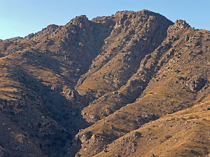
Views and solitude just off Lemmon Hwy by hwr   Overview OverviewA beautiful loop hike between Molino Basin and Agua Caliente Canyon in the Catalina Mountains, with great views of the Rincons and the Tucson basin. Except for one short stretch, the hike follows established (albeit unmarked) trails. A great way to get away from the crowds near Tucson and lead through the beautiful High-Chaparral / Yucca / Oak / Beargrass climate zone. Warning This is a hike on well-beaten hikers' paths, but they are not marked; the last part (1/2 - 1/3) of the hike follows the Arizona trail. To complete the loop, you have to either walk along Mt. Lemmon Hwy for 1/3 of a mile or follow Molino Canyon creek. A sense of orientation and the topo map are useful. While there are shindaggers at this elevation and along the trail, they are not a serious problem.
The first part of the hike follows a well-established hikers trail to a Rock Climbing area, the next part a very old and overgrown Jeep trail (seemingly used to maintain a waterline for a cattle trough). The last part is part of the AZ trail, leading from near the Belota ranch into Molino Basin. Hike The Hike starts at the Molino Canyon Vista pull-out and parking lot along the Mount Lemmon Hwy [the next marked parking after the Babad Do'ag pull-out; 1/3 of a mile before the toll booth] From the left edge of the parking area follow a trail down into the creek (paralleling the highway); cross the creek and turn right at a junction about 50 yards later; the trail then begins to climb, has a steep stretch after ten minutes and goes up on the east side of the drainage that meets Molino Canyon at the parking area. Switchbacks bring you to the ridge in 25 minutes. As you approach the ridge, stay left if unsure; it matters little which of the hiker's paths you take near the top (ending up about 100 yards east of the lowest point between elevation points 4831 and 4773). Once on the ridge, follow the trail as it goes level just south of the ridge, heading towards a west-facing rock wall, apparently popular with climbers. As you approach the top end of these crags the well-established trail seems to end and you'll encounter an old cattle fence, which is easily crossed just as you reach the rocks (you're now 100 yards southwest of point 4773). Views from the top of these crags of the Rincons, Agua Caliente Hill, the Tucson basin, and the ranges beyond are great. We found utter solitude on a nice December Sunday. The next 300 yards are the only orienteering challenge; you can't really go wrong, but there's no easily recognizable hiker's trail. From where you cross the cattle fence at the top of the crags (100 yards southwest of point 4773), you go 200 yards East, staying away from the cliffs on the south. As you approach a south-facing drainage you see (100 vertical feet below) an old, overgrown jeep-track running at constant elevation towards the pass that is 0.3 miles due east of point 4773. Follow indistinct deer tracks down to that jeep track and go east. There is a quite new plastic water hose partially buried along that track, leading to a watering trough at the pass and beyond. After the pass, there is now a good jeep trail following the unnamed drainage eastward (on the south side, well above the drainage). Along the track is a nice stand of oaks, seemingly unaffected by the 2004/05 fires. Follow this track for 1 mile until it meets up with the Arizona trail (0.2 miles southeast of point 4184). From there follow the AZ trail north over the pass northeast of point 5166 and then drop west into Molino basin. To head back to the starting point, continue on the Arizona trail until just north of the toll booth. From there. bite the bullet and walk down the highway back to the car for 1/3 mile. Water Sources Usually at Molino campground; in season at West Spring (in the Agua Caliente drainage) Check out the Official Route and Triplogs. Leave No Trace and +Add a Triplog after your hike to support this local community. | ||||||||||||||||||||||||||||||||||||||||||||||||||||||||||||||||||||||||||||||||||||||||||||||||||||||||||