Route Editor

| Guide | ♦ | 5 Triplogs | 0 Topics |
details | drive | permit | forecast | route |
stats |
photos | triplogs | topics | location |
| 57 | 5 | 0 |
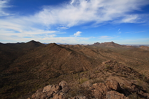
Bleed in solitude on a nice little desert peak by fricknaley  Overview OverviewThis is another partly off-trail route to another of the small peaks in the Tucson Mountains' northern foothills in the east and northern part of the West District of Saguaro National Park. Most of this hike is accomplished on trail, with a short off-trail scramble to bag the peak. Hike This hike takes off from the El Camino del Cerro/Sweetwater Trailhead on the eastern part of the Tucson Mountains, the only trailhead on this side of the mountains.
From here, you can head back the way you came for a short desert peak bag. A more exciting hike is to descend the summit's west slope to link back up to the Thunderbird trail and make a loop out in the desert with some other trails. To do this, descend the far west part of the southern slope and, as soon as possible, cut around the right to the west slopes of the peak and descend through some loose footing and cacti down the mountain. Notice that from the top, you can see the Thunderbird trail on the other side of the wash at the base of the peak. On your way down, aim for the wash whichever way you can. Once in it, climb up the other side and walk a very short way through the desert to link back up with the Thunderbird trail. Again you can head back here by going left. I recommend making a right onto the trail and heading north for about 0.5 miles or so to another trail intersection. This is the Cactus Canyon trail. Turn left onto this and almost immediately come to a park boundary and trail sign. Take this trail 0.9 miles to the Picture Rocks Wash, passing through absolutely pristine desert along the way. Once at Picture Rocks Wash. Turn left into the wash and hike it about 0.5 miles. To the right, climbing out of the wash is a sign for the Ironwood Forest Trail. Stay in the wash and very soon a sign marks to washed breaking away. Right is Picture Rocks continuing, left is Brittlebush. Take Brittlebush. A trail meanders about the right wall of the wash, or you can hike the wash south, which is what I usually do. In about 0.75 miles or so, a sign in the middle of the wash indicates the trail crossing over and climbing left out of the wash. Take this trail and climb back up into the desert for a short way. A sign marks the trail boundary again. Continue to a small saddle at the south base of Peak 3037. From here, descend a short way back to the unmarked intersection with the Thunderbird Trail. Turn right and head back to the Sweetwater Trail and trailhead for a 6.25-mile loop. Please tread carefully and respectfully through the desert.
Check out the Official Route and Triplogs. Leave No Trace and +Add a Triplog after your hike to support this local community. | |||||||||||||||||||||||||||||||||||||||||||||||||||||||||||||||||||||||||||||||||||||