 Route Editor

| Guide | ♦ | 3 Triplogs | 1 Topic |
details | drive | permit | forecast | map |
stats |
photos | triplogs | topic | location |
| 43 | 3 | 1 |
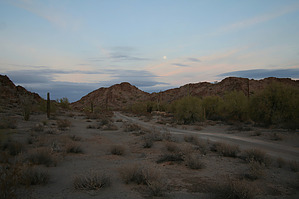
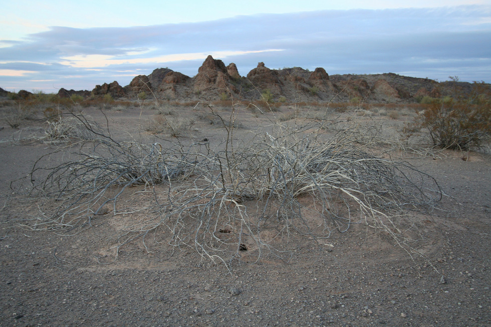
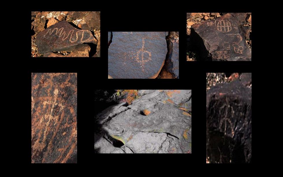
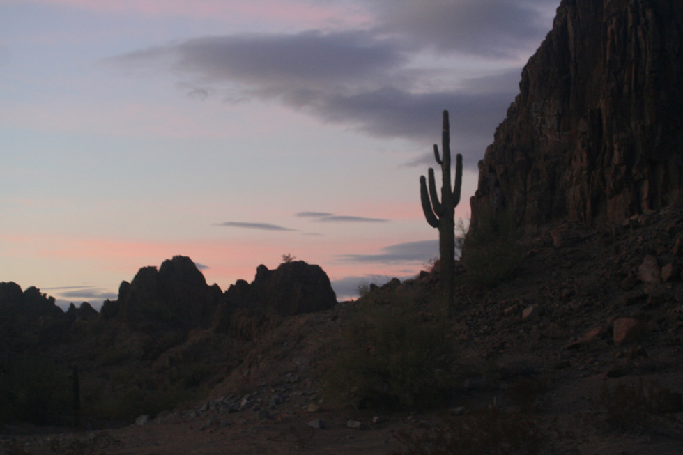
Volcanoes, Glyphs and Bombs by Randal_Schulhauser  History: Part 1 - Geologic History. About 10 miles of volcanic upheavals bisected by Hwy 85 comprise the Crater Range. Not a "crater" per se, but eroded remains of ancient volcanic activity including lava flows, layers of tuff, and volcanic breccia. The ridges are the remains of magma dikes, which are more resistant to erosion than the tuff surrounding them. The numerous spiked spires are remnants of volcanic conduits for molten magma. Similar in composition to the dikes, the spires are also more resistant to erosion than the surrounding tuff. History: Part 1 - Geologic History. About 10 miles of volcanic upheavals bisected by Hwy 85 comprise the Crater Range. Not a "crater" per se, but eroded remains of ancient volcanic activity including lava flows, layers of tuff, and volcanic breccia. The ridges are the remains of magma dikes, which are more resistant to erosion than the tuff surrounding them. The numerous spiked spires are remnants of volcanic conduits for molten magma. Similar in composition to the dikes, the spires are also more resistant to erosion than the surrounding tuff.Part 2 = Prehistoric Culture. Many traces of prehistoric human evidence dot the landscape. The Crater Range has numerous bedrock metates used to grind seeds and the rock art suggests the area could have been a significant hunting ground for Big Horn Sheep and Mule Deer. No evidence of permanent habitation has been established. Rock alignments and faint outlines of prehistoric trails further suggest the Crater Range was a transportation pathway that connected the North-South salt route from the Sea of Cortez through Charlie Bell Pass to Crater Range and onto the Gatlin Site and the Hohokam Pueblos of Phoenix.
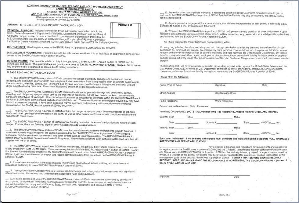
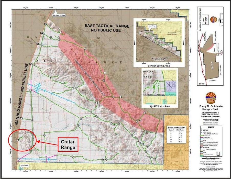
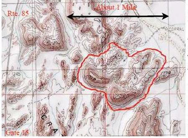
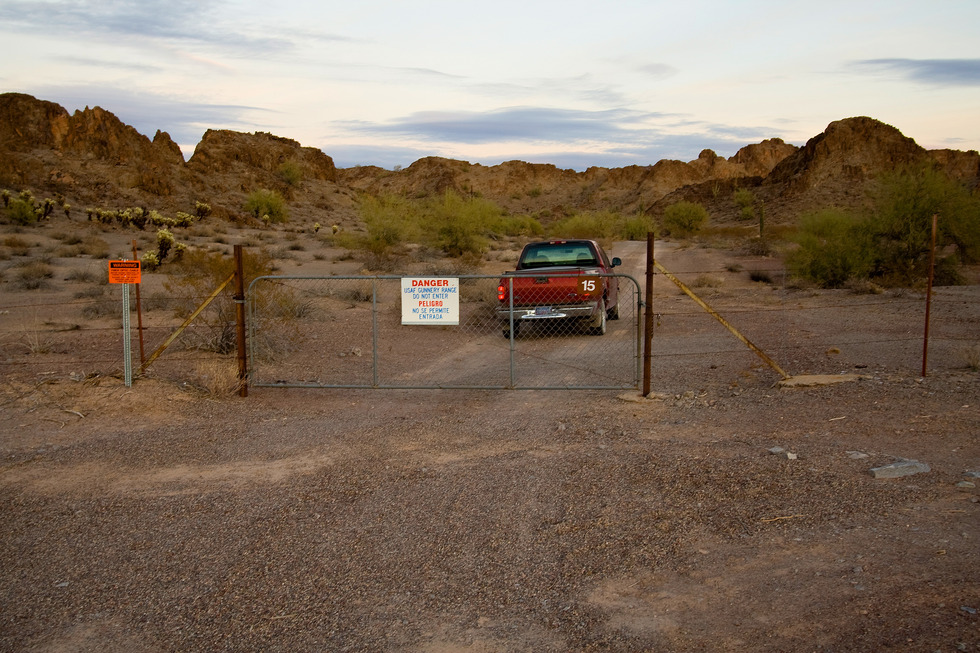
In addition to the soldiers stationed at desert training camps, thousands of fliers trained in the clear, desert skies of central and southern Arizona. Private contract flying schools began primary flight training at Phoenix's Sky Harbor Airport in 1939, Thunderbird Field in Glendale in 1940, Falcon Field in Mesa in 1941, and Thunderbird Field II north of Scottsdale in 1942. The Army Air Force contracted with Del Webb to build Luke Field in 1941, and Williams Field in 1942. In 1941, when Lieutenant Colonel Ennis Whitehead first surveyed the land for Luke Field, he also saw that the public lands south and west of Gila Bend could be used as an aerial gunnery and bombing range. The range was initially established in September 1941 and divided into eastern and western segments comprising 1.1 million acres. The western segment was identified as the Yuma Aerial and Gunnery and Bombing Range, while the eastern segment became the Gila Bend Gunnery Range, later known as the Ajo-Gila Bend Gunnery Ranges. The entire range was expanded during World War II by the progressive additions of six separate parcels until it totaled nearly 2.1 million acres by 1943. Executive orders and public land orders issued during President Franklin Roosevelt's administration were used to create the range by administratively withdrawing public lands and preserving them for use by the War Department as an aviation training area. Cadets came to Williams Field for basic flight training, and then to Luke for advanced flight training in single-engine aircraft. During the years of World War II, more than 17,000 pilots trained at Luke Field, making it the largest single-engine advanced flying training school in the U.S. More than a million hours of flying were logged, primarily in the AT-6 Texan, along with some transitioning to P-40 fighters and later the P-51 Mustang and other aircraft. Although continually modified during the war years, the course of advanced flight training at Luke averaged about 10 weeks and included both flight training and ground school. Approximately 60 hours of flying instruction covered formation flying, navigation, and instrument flying, as well as a bit of aerial acrobatics. About 20 additional hours of flight practice concentrated on aerial and gunnery training. Ground school, or classroom training for the advanced flying course, varied from about 100 to 130 hours and was intermingled with flight time in the aircraft. Cadets flew in the morning and attended ground school in the afternoons, or flew training missions in the afternoon after a morning of ground school. At the peak of the training program at Luke, some students were required to attend night classes. Ground school included instruction in navigation, flight planning, radio equipment, maintenance, and weather. The emphasis on gunnery training increased over time, as described by Jean Provence, historian of the 3600th Flying Training Wing in her 1954 history of Luke AFB: In the beginning, gunnery planes operated from Luke Field going to and from the Gila Bend Gunnery Range daily, leaving forty-five minutes after daylight and returning thirty minutes before dark. The first gunnery training was completed in one day and consisted of no more than allowing the student to fire his machine guns while his aircraft was airborne. Gradually the period of training was lengthened to three days, then six days, and finally two weeks. A veteran British Royal Air Force pilot, Wing Commander E.M. Donaldson, used his combat experience at the Battle of Britain to improve gunnery training during the spring and summer of 1942. In his 1942 report, Donaldson enthused about the range, saying, "No other school in the states can boast such a setup." Donaldson initiated the construction of dummy ranges for dry runs, the employment of the gun camera, the supervision of aerial gunnery missions by an instructor from an extra aircraft, and the allotment of permanent and specialized gunnery instructors... On 24 September 1942 two weeks of gunnery were made part of the Advanced Flying Training given at Luke Field and was conducted at the Gila Bend Gunnery Range from either Ajo or the Gila Bend Army Air Fields (Provence, 1954). Six auxiliary airfields were constructed in 1941-1942, each to a standard triangular configuration of three runways approximately 150 feet wide and 3,700 feet long. This configuration allowed the fields to be used under almost all wind conditions. Aprons were appended to one side of the runway triangles for parking aircraft. By 1944 student pilots from bases at Yuma and Kingman, as well as Las Vegas and Victorville, California, were being sent to Ajo and Gila Bend for gunnery training. The Chinese government also sent pilots to the United States for training, and some of them went through the advanced flying school and gunnery training at Luke. After several administrative deletions and additions to the range following World War II, the Goldwater Range reached its present size of 2,664,423 acres in 1962. These additions were required because the old World War II ranges were too small and close together to accommodate jet fighter aircraft. From 1946 - 1951 when Luke was closed, it was renamed the Williams Bombing and Gunnery Range. After Luke was reactivated and took over management of both the east and west components, the range was redesignated in 1963 as Luke Air Force Range, although the Marine Corps and Navy used the western side of the range for their training operations. Significant improvements were made to the range over the years. From 1952 to 1956, five air-to-ground gunnery ranges were improved, a tactical range was developed, and airspace above the complex was reserved for an air-to-air range. US Army ground liaison officers contributed to the improvement of tactical target scenarios. The Coronet Real project of 1975-1976 modified the tactical ranges for theater-specific scenarios: Europe, Middle-East, and Asia. Improvements included acquiring realistic targets, such as obsolete tanks and trucks. The completed tactical improvements significantly enhanced realism for pilots in air-to-ground ordnance delivery. Various types of jet fighters trained on the range over the years. The supersonic F-100 replaced the subsonic F-84; the F-4 and A-7 later replaced the F-100, while the F-5 and F-104 were introduced for foreign pilot training. The F-15 was used from 1974 to 1993, and the F-16 replaced the F-4 in 1983. Public Law 99-606, passed by Congress in 1986, renewed the range for 15 years by withdrawing and reserving all of the various parcels of the range in one legal instrument. It also renamed the range in honor of Senator Barry M. Goldwater, who had served as director of ground training at Luke during part of World War II. About one-third of the land area included in the Goldwater Range (822,000 acres) was set aside in 1939 by President Roosevelt as part of the 861,000-acre Cabeza Prieta National Wildlife Refuge (formerly known as the Cabeza Prieta Game Range). Although more than 95 percent of the wildlife refuge is within the Goldwater Range, military activities in the Cabeza Prieta portion are limited to four remotely located radio transmitters and flight training operations in the overlying airspace. Jurisdiction for all lands within the Refuge is the responsibility of the U.S. Department of the Interior Fish and Wildlife Service." Hike: I've driven along Hwy 85 through the Crater Range on several occasions and have been captivated by the unworldly landscape - sort of like Arizona's version of the Trona Pinnacles. To satisfy your curiosity, one must first obtain a valid BMGR/CPNWR/SDNM Permit. Outrageously priced at $0.00, I will describe the permitting process followed by the Cabeza Prieta National Wildlife Refuge headquarters located in Ajo AZ. You will be asked to watch a 30-minute video about the military range and desert backcountry hazards plus complete a HARMLESS Agreement. You will then be given your permits, area map, and access gate combination - all that in less than 45 minutes. The CPNWR will also be able to confirm that no planned military operations are closing BMGR public access. Armed with a GPS track posted on the "Cabeza Prieta Natural History Association" website by Thomas Powell, we found ourselves at BMGR Gate #15 on the east side of Hwy 85 at milepost 29.9 and about 11.3 miles north of CPNWR Headquarters. The combination provided opened the lock, and we were on our way bouncing along the double-track about 1 mile where it "peters out" beside a stone fire ring and a mound of empty beer bottles. This trail head provides multiple hiking opportunities. We decided to take a counter-clockwise loop. It's advised that you carry a GPS with you on this trek given the sameness of this maze-like terrain. We find scattered petroglyphs and bedrock metates along our path. Rumored panels of rock art could not be substantiated on this trek. Elevation gain is negligible following the valleys, but if you choose to, you can climb several volcanic dike ridges to gain some modest elevation. Summary: Preparing for a trek along El Camino del Diablo I became familiar with the permitting process to gain public access to what I thought were off-limit areas. Although it takes a little extra time to complete the requisite paperwork, this "pain" is easily offset by the hiking "gain" to areas rarely seen by human eyes! Enjoy! Gate Policy: If a gate is closed upon arrival, leave it closed after you go through. If it is open, leave it open. Leaving a closed gate open may put cattle in danger. Closing an open gate may cut them off from water. Please be respectful, leave gates as found. The exception is signage on the gate directing you otherwise. Check out the Triplogs. Leave No Trace and +Add a Triplog after your hike to support this local community. | ||||||||||||||||||||||||||||||||||||||||||||||||||||||||||||||||||||||||||||||||||||||


