Overview: From the Lakes Road the trail heads northeast past the Twin Tanks, then mostly north crossing several small roads. It turns briefly to the west and then back north again, crossing several more roads and then reaching Sahuarita Road. It loops north and then east and goes under Highway 83 at a culvert. After a short traverse across the desert it crosses the Old Sonoita Highway and then joins a two-track road. After several road junctions, including a powerline access road, it leaves the road and heads north up to Interstate 10. After going under I-10, it climbs up onto a ridgeline and follows that to the Davidson Canyon Gabe Zimmerman Trailhead.
When hiking several trails on a single "hike", log it with a generic name that describes the hike. Then link the trails traveled, check out the example.
WARNING! Hiking and outdoor related sports can be dangerous. Be responsible and prepare for the trip. Study the area you are entering and plan accordingly. Dress for the current and unexpected weather changes. Take plenty of water. Never go alone. Make an itinerary with your plan(s), route(s), destination(s) and expected return time. Give your itinerary to trusted family and/or friends.
Permit $$
no fees or permits reported
if incorrect tell us about it
Directions
Road
To hike
page created by joebartels on Jan 09 2010 12:40 am
 Route Editor

 Overview: From the Lakes Road the trail heads northeast past the Twin Tanks, then mostly north crossing several small roads. It turns briefly to the west and then back north again, crossing several more roads and then reaching Sahuarita Road. It loops north and then east and goes under Highway 83 at a culvert. After a short traverse across the desert it crosses the Old Sonoita Highway and then joins a two-track road. After several road junctions, including a powerline access road, it leaves the road and heads north up to Interstate 10. After going under I-10, it climbs up onto a ridgeline and follows that to the Davidson Canyon Gabe Zimmerman Trailhead.
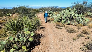


