Overview
This entire passage is on the Mazatzal Divide Trail #23. From the junction with the Cornucopia Trail 0.5 miles from the Mt. Peeley Trailhead, the route works its way up and around Mt. Peeley. It passes the wilderness boundary, gets around the head of a drainage, and then turns to the north and follows a ridgeline. It circles counter-clockwise around an unnamed peak and then descends to the Bear Spring turnoff. It climbs up and over the previous ridgeline and drops down to the Shake Tree Trail junction. From here the trail continues north and downhill, passing Mazatzal Peak. The trail climbs and then drops again down to the Barnhardt Trail junction. Turning west the trail continues downhill, passing Chilson Spring, contouring for a short way, and then climbs above the North Fork of Deadman Creek. It passes Horse Camp Seep, continues climbing, and reaches Hopi Spring. The trail crosses the upper end of Deadman Creek, heads west, and then turns north and begins descending along the east side of Maverick Basin. The trail continues northbound and then turns to the west and comes to The Park and the intersection of the North Peak Trail #24. A few miles further north it reaches the end of the passage at the Red Hills Trail junction.
Southern Trailhead Mt Peeley TH
Drive 4.8 miles north of Sunflower/Bushnell Tanks on AZ 87 to MP 222.8. Turn left (west) onto a paved road (FR 627) which is opposite the Mt. Ord turnoff. Follow FR 627 downhill for 1.2 miles and then turn right over a cattle guard onto FR 201. Drive 9.3 miles on FR 201 to Mount Peeley TH where there is a small parking area. The sign here says Cornucopia Trail #86 and indicates a 0.5-mile hike to Mazatzal Divide Trail #23 and the AZT.
Northern Trailhead Red Hills Trail Junction
From Payson on AZ 87 drive west on Main Street. Stay on the main road past a golf course, where the pavement ends and the road becomes FR 406. About 10 miles from AZ 87, park at City Creek Trailhead on the east side of the road. Hike southwest up the Mazatzal Divide Trail #23 for approximately 5.75 miles to the junction of the Mazatzal Divide trail and the Red Hills Trail.
When hiking several trails on a single "hike", log it with a generic name that describes the hike. Then link the trails traveled, check out the example.
WARNING! Hiking and outdoor related sports can be dangerous. Be responsible and prepare for the trip. Study the area you are entering and plan accordingly. Dress for the current and unexpected weather changes. Take plenty of water. Never go alone. Make an itinerary with your plan(s), route(s), destination(s) and expected return time. Give your itinerary to trusted family and/or friends.
Permit $$
no fees or permits reported
if incorrect tell us about it
Directions
Road
To hike Mount Peeley: Usually closed for winter and not advised when wet. Drive 4.75 miles northeast of Sunflower, AZ on AZ 87 past mile marker 222. At the top of the long climb, turn left (west) onto FR 626. Drive 1.25 miles on this winding paved road to a junction with a gravel road entering from the right. Cross the cattle guard and drive another 1.25 miles to a 3-way junction; stay right on to FR 201 and continue 9.5 miles along this narrow, twisting road to the Mount Peeley trailhead and a small parking area. The AZT is 0. 5 miles west of the parking lot along the Cornucopia Trail (#86) where Passage 22 lies to the south, and Passage 23, also called the Mazatzal Divide Trail, heads north.
page created by joebartels on Jan 09 2010 12:41 am
 Route Editor

 Overview
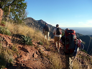


