 Route Editor

| Guide | ♦ | 46 Triplogs | 1 Topic |
details | drive | no permit | forecast | 🔥 route |
stats |
photos | triplogs | topic | location |
| 558 | 46 | 1 |
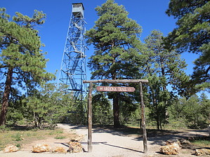
grand encounter by HAZ_Hikebot  This passage begins at the Grandview Lookout Tower and starts out on the Tusayan Bike Trail heading west. It works its way through the forest, drops into a drainage, and reaches Watson Tank. Now on forest roads, the route turns to the north and joins FR 303. It becomes singletrack, works its way over to the junction with FR 303D, and turns to the north on this road. When it comes to the end of FR 303D, the route becomes singletrack again, passes Upper Ten X Tank, goes through a gate, and then joins FR 2710B. It follows this road to FR 2710 and then turns on to FR 9122E. It follows this road, passes a junction with FR 2709, and comes to Coconino Wash. It turns northwest and follows Bike Route 3 and then 2, which leads to Bike Route 1. This passage begins at the Grandview Lookout Tower and starts out on the Tusayan Bike Trail heading west. It works its way through the forest, drops into a drainage, and reaches Watson Tank. Now on forest roads, the route turns to the north and joins FR 303. It becomes singletrack, works its way over to the junction with FR 303D, and turns to the north on this road. When it comes to the end of FR 303D, the route becomes singletrack again, passes Upper Ten X Tank, goes through a gate, and then joins FR 2710B. It follows this road to FR 2710 and then turns on to FR 9122E. It follows this road, passes a junction with FR 2709, and comes to Coconino Wash. It turns northwest and follows Bike Route 3 and then 2, which leads to Bike Route 1.The route curves to the north behind the town of Tusayan. A short climb and descent leads to a road junction and a turn to the west. The trail goes under Highway 64 and turns north. The Tusayan Bike Trail (which the AZT follows) ends 0.3-mile north of Tusayan. From that point, the AZT is signed across the old Moqui Lodge area, about 0.5-mile to the GCNP boundary fence. From the gate, the route is signed all the way to the South Kaibab Trailhead.
Southern Trailhead: Grandview Point - Grandview Lookout Northern Trailhead: Yaki Point - South Kaibab TH Gate Policy: If a gate is closed upon arrival, leave it closed after you go through. If it is open, leave it open. Leaving a closed gate open may put cattle in danger. Closing an open gate may cut them off from water. Please be respectful, leave gates as found. The exception is signage on the gate directing you otherwise. Check out the Official Route and Triplogs. Leave No Trace and +Add a Triplog after your hike to support this local community. One-Way Notice This hike is listed as One-Way. When hiking several trails on a single "hike", log it with a generic name that describes the hike. Then link the trails traveled, check out the example. | ||||||||||||||||||||||||||||||||||||||||||||||||||||||||||||||||||||||||||||||||||||||||||||||||||||||||||||||||||||||||||||||||||||||||||||||||||||||||||||||||||||||||||||||||||||||||||||||||||||||||||


