|
tap row or icons for details
|
| Difficulty |
|
4 of 5 |
| Route Finding |
|
1 of 5 |
| Distance One Way |
|
22.3 miles |
| Trailhead Elevation |
|
4,074 feet |
| Elevation Gain |
|
2,491 feet |
| Accumulated Gain |
|
3,870 feet |
| Kokopelli Seeds |
|
35.2 |
| Backpack Yes & Connecting | |
| | |
|
|
6 |
2024-04-26 | kyleGChiker |
|
|
24 |
2024-04-13 | DarthStiller |
|
|
11 |
2023-11-17 |
AZ Trail Gardner Canyon |
markthurman53 |
|
|
|
5 |
2021-04-07 | ttretta |
|
|
12 |
2020-11-21 | trekkin_gecko |
|
|
9 |
2020-11-21 | johnlp |
|
|
1 |
2019-10-25 | toddak |
|
|
3 |
2019-03-02 |
Old Pueblo Endurance Run 25 Miler |
fricknaley |
|
| | Page 1, 2, 3, 4, 5 |
| |
|
|
|
list |
map |
done |
Tucson Region |
| | |
|
| |
|
|
Historical Weather |
| Trailhead Forecast | | |
|
 |
| | | |
| |
Named Locations Coordinate Links
| |
|
| Temporal Gulch - AZT #4
|
21.96 mi
4,037 ft |
|
|
| Temporal Gulch - AZT #4
|
21.86 mi
2,541 ft |
|
|
| Temporal Gulch - AZT #4
|
22.88 mi
3,779 ft |
|
|
| Temporal Gulch - AZT #4
|
24.29 mi
3,596 ft |
|
|
| Temporal Gulch - AZT #4
|
3.85 mi
144 ft |
|
|
| Temporal Gulch - AZT #4
|
24.4 mi
3,916 ft |
|
|
| Temporal Gulch - AZT #4
|
22.78 mi
3,410 ft |
|
|
| Temporal Gulch - AZT #4
|
13.08 mi
2,253 ft |
|
|
| Temporal Gulch - AZT #4
|
2.69 mi
240 ft |
|
|
| Temporal Gulch - AZT #4
|
22.01 mi
2,531 ft |
|
|
| Temporal Gulch - AZT #4
|
6.01 mi
625 ft |
|
|
| Temporal Gulch - AZT #4
|
22.28 mi
3,536 ft |
|
|
| Temporal Gulch - AZT #4
|
21.36 mi
3,380 ft |
|
|
| AZ Trail Gardner Canyon
|
8.1 mi
837 ft |
|
|
| Temporal Gulch Reroute
|
10.77 mi
1,156 ft |
|
|
| Santa Ritas mega loop
|
26.3 mi
7,054 ft |
|
|
| Old Pueblo Endurance Run 25 Miler
|
25.71 mi
3,462 ft |
|
|
| Temporal Gulch - AZT #4
|
3.57 mi
301 ft |
|
|
| Arizona Trail Passages 4-5
|
37.81 mi
5,646 ft |
|
|
| Arizona Trail along Road at Patag...
|
10.62 mi
595 ft |
|
|
| Wrightson via Temporal to Walker ...
|
17.7 mi
5,227 ft |
|
|
| AZT Passages 4-5
|
20.43 mi
2,939 ft |
|
|
| AZT #4 Temporal Canyon to Walker ...
|
12.77 mi
1,961 ft |
|
|
| AZT #4 Walker Basin to Gardner ca...
|
19.33 mi
2,370 ft |
|
|
| | |
| |
|
|
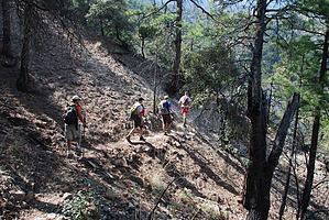
Passage 4 begins with a long ascent into the Santa Rita Mountains, a rugged sky island range with steep slopes and granite peaks. This section features incredible biodiversity and is home to rare birds and some plants that occur nowhere else outside of Mexico. Mount Wrightson, the high point of the Santa Rita Mountains, rises to an elevation of 9,453 feet and has a distinctive pyramid peak that can be seen throughout much of this section. Trail users may follow connector trails on the Coronado National Forest to reach this iconic summit. Starting from the Casa Blanca Canyon Trailhead, this section begins in a grassland ecosystem and climbs through oak savannah to reach the sweet-smelling oak-pine forest on the edge of the Mount Wrightson Wilderness. Early in spring, it is not uncommon for snow to remain on the higher peaks and hillsides of this wilderness. This passage features some of the most recently built miles of the AZT. After decades of sharing alignment with dirt roads north of the town of Patagonia, the Temporal Gulch Reroute Project improves safety for trail users and provides a National Scenic Trail experience through the construction of 32 miles of trail. Construction began in the Spring of 2020 and is anticipated to be finished by the Summer of 2023. Consult information at trailheads and along the trail to follow the most scenic route, as new segments are opened as soon as they are finished. Check out the Triplogs. NoteThis is a moderately difficult hike. One-Way NoticeThis hike is listed as One-Way. When hiking several trails on a single "hike", log it with a generic name that describes the hike. Then link the trails traveled, check out the example. |
 Route Editor


