Route Editor

| Guide | ♦ | 27 Triplogs | 0 Topics |
details | drive | permit | forecast | route |
stats |
photos | triplogs | topics | location |
| 202 | 27 | 0 |
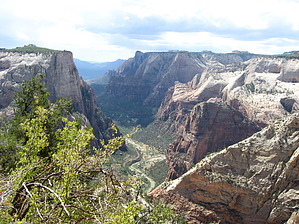
Grandiose views by nonot A mostly paved trail to an excellent vista over the main canyon of Zion National Park. Warning This trail is not for those with an extreme fear of heights. In the summer it can be quite hot, but an early start will be beneficial and result in getting shade for much of the hike. The earlier the start, the greater the percentage of the time you will get shade in the upper sections. The lower half of this trail will stay shaded until nearly noon.
Early trail construction often involved blasting trails into the slick rocks and cliffs of the park. This is a popular trail but seldom is it crowded (in contrast to the Angel's Landing hike.) Hike From Weeping Rock trailhead, get off the bus and follow the road 100 ft up canyon and turn right into the parking area. Cross the small footbridge near the restroom and go straight (going left takes you to weeping rock). From here the trail is basically all uphill. The first section is the paved switchbacks that go up the cliff along the main part of Zion Canyon. The Hidden Canyon trail will depart about half way up. After many switchbacks the trail will level somewhat and turn east. It crosses over the drainage of Echo Canyon and goes up the slickrock and underneath a semi-tunnel section next to this dark, cool, canyon. Cross bedded sandstone can be observed on the walls of the canyon before and after this traverse. The trail winds around a feeder drainage of Echo and uses a small bridge to get over this micro-slot. Some sand is encountered and the trail gets into the sun where it wanders up-canyon. It will begin climbing and reach the intersection between the echo canyon trail and the observation point trail. Stay on the observation point trail. From here you will go up 11 switchbacks and one curve until you reach the elevation of the east rim. Finally near the top you are done with elevation and the trail continues north in the red soil with awesome views to your left down below you. You will reach a sandy intersection with the east rim trail and here you turn left and head the final short distance onto the observation point peninsula. At the very end is the spectacular vista known as Observation Point in which you can look down on Angel's Landing as well as most of the main canyon of Zion with great views of the Virgin River far below. Return the way you came. Water Sources None, bring plenty. Camping In Zion Nat'l park at the South Campground or Watchman.
Check out the Official Route and Triplogs. Leave No Trace and +Add a Triplog after your hike to support this local community. | |||||||||||||||||||||||||||||||||||||||||||||||||||||||||||||||||||||||||||||||||||||||||||||||||||||||||||||||||||||||||||||||||||||||||||||||||||||||||||||||||||||||||||||||||||||||