 Route Editor

| Guide | ♦ | 13 Triplogs | 1 Topic |
details | drive | permit | forecast | 🔥 route |
stats |
photos | triplogs | topic | location |
| 142 | 13 | 1 |
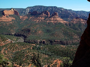
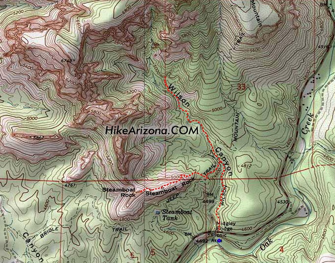
Salad and burger by joebartels   Here I've combined two hikes into one, as both are relatively short. Included below are the statistics for an individual hike on either of the two. Here I've combined two hikes into one, as both are relatively short. Included below are the statistics for an individual hike on either of the two.Wilson Canyon Trail: 2.8 miles RT - 372 feet elevation gain Steamboat Rock: 2.7 miles RT - 723 feet elevation gain
The trail crosses an intermittent streambed several times along the way. This was one of the more relaxing hikes I recall to date. It was borderline hot at 86 degrees with a late start in March. I was expecting full exposure as most Sedona hikes dish up. Midway up the canyon, I realized this hike was better than expected. Although far from shady, an occasional section is enjoyed. It's a simple hike. You go up the canyon, and the trail peters out. A distinctive trail-of-use takes off on your right up the steep slope. You can go up the first tier pretty easily and get in some great views. If you want better views, go up further until you reach a wall. It's not much more difficult but probably not for younger kids. I say that because I imagine tourists heavily travel this trail. I passed two families on a Thursday in March and a few couples, none of which looked like serious hikers. On the way out, I tacked on Steamboat Rock. This isn't for families with young kids. At Jim Thompson junction, jump on that trail. It's something like an eighth of a mile to the obvious jump-off point. Cairns will likely be in place to assist you. If not, you'll figure it out. It's up! You can head straight up if you have a little climber in you. Otherwise, minor zig-zagging will do the trick. You will know when you reach the deck "of the Steamboat." It's flat as a pancake and without a doubt, the most significant smooth chunk of red rock at such altitude. You can work your way up to the upper deck, but a minor climbing move is involved. If you fell, you'd seriously hurt yourself. However, I don't think you'd die because there's a slight break in the grade and a tree to keep you from rolling off the mountain. Regardless of how high you go, the views are AWESOME! I don't recommend screwing around on the slanted edges. Leave the hearty boots at home. Red rock slabs are best tackled in running shoes or tevas, in my opinion.
Check out the Official Route and Triplogs. Leave No Trace and +Add a Triplog after your hike to support this local community. | |||||||||||||||||||||||||||||||||||||||||||||||||||||||||||||||||||||||||||||||||||||||||||||||||||||||||||||||||||||||||||||||||||||||||||||||||||||||||||||||||||||||||||||||||||||||||||||||||||||||


