Route Editor

| Guide | ♦ | 188 Triplogs | 0 Topics |
details | drive | no permit | forecast | route |
stats |
photos | triplogs | topics | location |
| 431 | 188 | 0 |
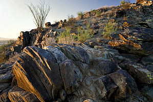
Crowd Thinner! by joebartels  Piestewa Peak is often touted as the busiest inner-city trail. South Mountain is only being held back by a lack of parking. On a Saturday morning in June with an expected high of 110 degrees, hiker's backed up parking nearly a mile before 8 am. Holy cow, you'd think you're at the beach in California, not! Luckily I arrived pre-dawn. The gates open around 4:45 am, and it loads up quickly. Piestewa Peak is often touted as the busiest inner-city trail. South Mountain is only being held back by a lack of parking. On a Saturday morning in June with an expected high of 110 degrees, hiker's backed up parking nearly a mile before 8 am. Holy cow, you'd think you're at the beach in California, not! Luckily I arrived pre-dawn. The gates open around 4:45 am, and it loads up quickly.This hike is referring to the Guadalupe Ridge-Ridgeline, not the better know "Ridgeline Trail" which connects Beverly and Javelina canyons. From the trailhead, cut through the ramadas and head over and up to the Marco de Niza inscription rock. Grab a copy of Day Hikes and Trail Rides in and around Phoenix for information on the rock and the history of Guadalupe. From inscription rock, a trail continues up to the left. This is your access to the Guadalupe Ridge, which was named before the sprawl of Ahwatukee. Follow this bad boy for 2.6 miles. It's a rollercoaster ride but most certainly worth the effort. The accumulated elevation gain is comparable to that of Echo Canyon Trail on Camelback. Here it's stretched out over 5.5 miles, so it's nothing as brutal.
Continue west and up from the telephone lines. It's steep going up. Amazingly, it's often mountain biked. The ups and downs continue. You will need to pay attention to keep on the ridge. The trail most easily follows back down to the Pima Canyon Trailhead, so if you find yourself going OVER and down, it's time to backtrack. Did I mention the views are top-notch! You even have the San Tans in view, which tends to be a spec on the horizon from most other Valley peaks. Okay, so you're past the turnoff down to Pima Canyon Trailhead. You won't find any crowds up here, but you never seem to be "alone" on South Mountain. The trail narrows. It continues to be fairly easygoing. The tricky spot has already been passed. There are a few areas that become non-distinct due to rocks or boulders. Keep up on the ridge. I believe I took every "sucker" path on my first attempt. The trail holds up pretty well to a section where you pass between two bathroom-sized boulders. After this, cairns come into play due to the lack of vegetation and an abundance of small boulders. Maybe now would be a good time to mention you'll need a good grasp of the Hidden Valley area to complete this hike. Continue until you see the Hidden Valley signed junction way down below. You may have to squint, but I didn't think it was too difficult to spot. A rock-ridge takes you directly down over Fat Man's Pass. If you have a good grasp of the area as mentioned above, you know the way home. If not, you really shouldn't be here. If you continue along the ridge, you will drop off into Eagle Pass. The National Trail swings over, but I think the rock ridge down to Fat Man's Pass is best! Please Note: Many trails in the park have been staked with yellow off-limit signs or camouflaged. As of this writing, the entire length of this route showed no signs of being closed to the public and a well-beaten path in vegetation areas. If that changes, you shouldn't cross off-limit areas. Check out the Official Route and Triplogs. Leave No Trace and +Add a Triplog after your hike to support this local community. | |||||||||||||||||||||||||||||||||||||||||||||||||||||||||||||||||||||||||||||||||||||||||||||||||||||||||||||||||||||||||||||||||||||||||||||||||||||||||||||||||||||||||||||||||||||