Route Editor

| Guide | ♦ | 46 Triplogs | 6 Topics |
details | drive | permit | forecast | route |
stats |
photos | triplogs | topics | location |
| 865 | 46 | 6 |
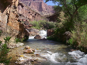
WOW! by desertgirl  Overview OverviewTapeats Rapids via Bill Hall Trail and Thunder River Trail. Hike This is an excellent trip with some incredible vistas, interesting & challenging switchbacks, and dicey trails on the descent to Upper Tapeats Campground (a loaded pack makes it harder) and along the West high route to Lower Tapeats Camp/River. We did this as a 5day/4 night trip -- which made it rather comfortable. I love waking up in the canyon, so I enjoyed every bit of it.....
After having done the whole trail down to Lower Tapeats, I think this is the easiest descent/ascent (of this trip) despite its reputation for a difficult trail. It's short & is over with quick. (I have not done Thunder River, but I cannot see myself adding 5 more miles to get down to the Esplanade). It does have some steep descents right at the start, and one 15 ft climb down/up over an outcropping. We were all able to negotiate it quite easily - a helping hand with the pack is all that was needed here. If you are going solo; make sure you are playing safe here.. It's just not worth becoming another statistic. As will almost all Grand Canyon trails; watch out for the exposure and unstable trails. Soon (~ 3/4 miles later), you are at the Bill Hall Trail & Thunder River Trail intersection and on the Esplanade. The traverse through the Esplanade was pleasant, and we were treated to interesting rock formations - reminiscent of Canyonlands, I am told! The trail is pretty flat except for a few minor drainage crossings. Follow the cairns across the slick-rock and try to minimize the impact to the fragile crypto-biotic soil that seems to be everywhere on the Esplanade. You begin to wind your way around 3 drainages of Deer Creek. Junipers, yucca, and prickly pear cactus dot the area beautiful offset against the red rocks. You reach a series of rock caves (some have been improved upon with rock walls and cleared floors) about 30 mins from the intersection. This seems to be a good cache spot, and you do have views out west across the Esplanade. We picked up our water cache for dry camp on the Esplanade at the edge of the next descent. The trail turns westwards as it heads towards the break in the Redwall where it descends into Surprise Valley. Pitched camp right along the edge, and we were treated to a great sunset (the only beautiful sunset for this trip). Spirits were high; the company was great, blisters were a few days away, and all was perfect. We departed early, making the descent through the Redwall into Surprise Valley in the morning shade. This is a rather long descent along a fault /slump in the Redwall. Well constructed switchbacks make it reasonably easy. You make your way along Surprise Valley and soon are at the intersection of the Thunder River & Deer Creek trails (not signed but marked by cairns). Keeping left, we continued along, winding our way by Cogswell Butte and a few other buttes (?); climbing as we headed to the head of Thunder River drop off. We could hear the roar as we descended the trail, making us eager for our 1st glimpse - it was beautiful indeed with the ribbon of greenery winding downstream with a small spray catching the morning sun bursting into millions of crystals as it fell downwards to join the band of greenery. This was just the angle that I stopped and the perfect morning sun angle - I never did see that again. As you make your way down this moderate descent Thunder River quickly reveals itself, gushing out of the sheer cliffs. You descend through Muav Limestone and Bright Angel shale (grey-green). You reach a greenish, small flat area, and a spur heads of towards the river. We dropped out packs and headed to view Thunder River. What a magnificent sight - water pouring out of the wall and heading downhill in a series of waterfalls, each different and unique and absolutely beautiful. (Especially after a sweltering hike through Surprise valley -- Surprise Valley traverse seemed short, but then again, it was at 8:00 am). The water is ice cold and the falls are lined with beautiful clumps of scarlet monkeyflowers, ferns, watercress, and moss. The fine spray was a welcome relief -- we played around for quite a while. An interesting juxtaposition of the harsh desert environment and the riparian belt of lushness that follows the water set amid the towering cliffs that is Grand Canyon indeed. Reluctantly, we came back out to the trail and once again hoisted our packs to head down to the Upper Tapeats campground. We had wonderful visions of campsites by the stream with trees overhead. The trail gets harder here as it makes its way through crumbling layers of Bright Angel Shale with 200+ ft drops on one side and towering cliffs on the other. There are some sections where the trail moves away from Thunder River and flattens a bit, finally plunging to the Tapeats Creek level with a series of fairly steep switchbacks. You are treated to plunging waterfalls as Thunder River races down to join Tapeats Creek in less than 1/2 mile. We camped at the Upper Tapeats Campground (about 200 yards from the confluence). Overall a disappointment- no wonderful shade or babbling water right by camp (1st large site, we did locate some slightly better campsites further downstream), but we did have a rock bench to set up kitchen and a smidgen of shade we could hide in. We set up camp, lounged about a bit, and then decided to go and check out the confluence of Thunder River & Tapeats Creek. This was a beautiful place laced with ferns and monkey flowers, and small babbling waterfalls. We were impressed by the flow in Tapeats Creek! We hung about there a bit. Ed was having a bit of dehydration and decided to hang back and hydrate in the shade. The rest of us decide to explore Tapeats Creek. We forded the confluence and the creek and headed up the east bank. We clambered over a few rockfalls, beat back some bushes, and mostly followed a path. Soon we passed a good campsite and reached a ford in the creek. Terri elected to return to keep Ed company, and Matt & I headed further upstream. Just past the ford was another great campsite. We headed on for about another 30 mins, crashing through bushes (looked like the creek had flooded not in the too distant past) and negotiated a few more rockfalls, encountered a snake that was hell-bent on getting away from us (no objections here!). Soon the trail petered out & we elected to return. I think we made about a mile or so upstream. We were soon back at the camp and soon waiting for the sun to dip below the canyon to get shade on the campsite. Camp was set up quickly, and dinner followed. Soon Matt was battling the red ants, scorpions, and mice (We did lose part of our cheesecake to the mice). He had decided to go light without a tent, and I am sure he has since re-evaluated weight vs. fighting creatures! The next morning was our planned hike to the Lower Tapeats! This looked a bit grim as Ed was still recovering, and we debated a bit and then decided Ambika & Matt would take a trip down to the river while Ed & Terri would rest up. Terri was really nice and decided to let me have her Tevas (I had flip-flops for camp slippers) for this hike. This was wonderful since it gave my toes a break from being smashed into my hiking and was ideal for the couple of creek crossings we would encounter on the way back. The shade was there, so we headed out the high route on the west side, making it most of the way in shade. The west route goes high following the rock layer contours dipping down to the creek about 5 times via rocky steep switchbacks. The route is fairly easy to follow but quite narrow with loose crumbling rock underfoot... a pack would make the high route a definite challenge, and it is quite a risk if you even have the slightest fear of heights or exposures. The east route is way better and easier as we would find on our way back. You are high above the creek as it hurtles down through several waterfalls through the narrows of dark blue-black diabase as it heads towards Colorado. We ended up high above the Colorado on the last section, looking down onto Lower Tapeats beach, where a private raft trip was just pulling in. Soon we saw the cairn that pointed the way down to the beach by way of a steep, narrow, rocky draw with about 300+ ft drop in less than 1/2 mile. We ford the creek one more time to meet up with the raft party, mooch some cookies off them, and hang out with them about an hr or so. Soon we are heading back... We explore the east route... It leads high up on the east side; we decide to head back to the west route for the 1st part and then cross over to the east side. We soon cross East and wander along the creek bottom, negotiating a few rock-falls and small climbs-ups, making excellent time heading back to camp. We pause by a short but beautiful waterfall where the Tapeats Creek pours over a layer of Bass Limestone. We ford back to our camp and crawl up under the rocks looking for shade. Ed thermometer registers 127 degrees in the sun. We soon relocated to the streamside for some cooling breezes. Late in the evening, we decide to hike up out of Thunder River and camp up in Surprise Valley. This lets us climb out in the relative cool of the evening. Ed's still recovering, so we make the best use of the shade... we barely make it out of Thunder River in fading light after a brief stop at the falls on our way out, camping right at the head of the descent. I break a tent pole & its duct tape to the rescue. Mice run rife through camp - we were lucky not to lose pack to their sharp teeth. It is still too hot.... Morning sees Ed in much better spirits, and soon we are up above Surprise Valley. Again morning shade on the Redwall ascent was great. We soon make our way across the Esplanade to the caves and hide for the rest of the afternoon and feast on our cache, and time hangs on us... on a cooler day with lighter backpacks, we might have pushed on out. We make our way to the base of the final ascent and camp for our last night in. We soon realize we are sharing camp with a tarantula. We decide to co-exist but end up relocating the tarantula. It gets quite windy for a while, but soon the still warm air descends upon us one last time. Discussion seems to center on BO... Matt fights off more mice... Sunrise and we are soon making our way out back to the Jeep. Clean clothes... long drive to Flagstaff... lunch at Weatherford Hotel... drive back to Phoenix... shower, and we all will have stories tell... looking forward to the next trip... The enchantment continues! Synopsis Different opinions rage on the difficulty of this trip - Be prudent and don't get in over your head. The trip turned out easier than what I was led to believe based on trail descriptions. If you are an aggressive hiker, fearless of crumbly trails and sheer drop-offs, sure-footed, and with a light pack - you can do this in a 3-day trip, but you will be moving all the while. We would have been fine to shorten the trip by a day. Cooler weather would be much better since you do not need to haul as much water but don't short change... you are a long way off from help even if you make it to the trailhead. Check out the Official Route and Triplogs. Note This is a more difficult hike. It would be unwise to attempt this without prior experience hiking. Leave No Trace and +Add a Triplog after your hike to support this local community. | ||||||||||||||||||||||||||||||||||||||||||||||||||||||||||||||||||||||||||||||||||||||||||||||||||||||||||||||||||||||||||||||||||||||||||||||||||||||||||||||||||||||||||||||||||||||||||||||||||||||||||||||