 Route Editor

| Guide | ♦ | 165 Triplogs | 1 Topic |
details | drive | permit | forecast | route |
stats |
photos | triplogs | topic | location |
| 1k | 165 | 1 |
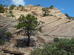
Smorgasbord of Awesome by joebartels   This out and back hike up Bear Mountain is the ultimate Sedona geology lesson. From the trailhead, it appears you will be walking across a boring flat plain to get over to the mountain. In reality, it's a roller coaster through deep-ditch-erosion. On the return trip, you get a beautiful view of these ditches as they spider across the desert floor. This out and back hike up Bear Mountain is the ultimate Sedona geology lesson. From the trailhead, it appears you will be walking across a boring flat plain to get over to the mountain. In reality, it's a roller coaster through deep-ditch-erosion. On the return trip, you get a beautiful view of these ditches as they spider across the desert floor.In a little over a quarter-mile, you're at the base of Bear Mountain. The fun begins. You are starting in the lower section of Schnebly Hill Sandstone. It's a huffer 350 ft ascent to a deck etched out by Fort Apache Limestone. As you're gasping for air, keep in mind you haven't even cleared a quarter of the climb yet!
Next, you move across a more defined and distant deck covered with lots of manzanitas. This deck is the split of Schnebly Hill Sandstone, followed by Coconino Sandstone. When the incline picks up again in a half-mile, you'll notice the distinct difference. The Coconino is orange instead of red. Continue to work up through approximately 500 ft of Coconino. Cairns become more plentiful. The first pine encountered is all by itself. This bad boy doesn't look old. Another look at all the pinecones strewn about makes you wonder. Further on is a real treat. It's a multi-directional etched-section-swirl of sandstone. This is unlike any other area around Sedona I've seen. It's more reminiscent of northwestern Arizona or Utah. Just fascinating. At first, it appears you'll get to go straight up through the heart of swirls. However, the cairns detour you right. Further up is yet another deck of sorts. I don't recommend exploring this deck. Stick to the cairns. It's a maze of manzanita-lined-ravines of plate-rock. I might add, a topographical map would be wise for this hike. Continue up the last section. The footing becomes a bit more technical. Once atop Bear Mtn, you're on your own. It's a scraggly forest with thick bush and such. A trail does sort of skirt the outer edge. Work your way around. The views are breathtaking every few steps. In sections, pitted Kaibab Limestone is cool as it lips the edge. Be careful, and those aren't diving boards. The top I describe is a tiny elevated island. You'll notice the bulk of Bear Mountain is further north past a saddle (which BTW is the break above the boxed-in-canyon-end of the Boynton Canyon Trail). It may be possible to work through the shrubs to either of those destinations. However, I think it'd be too painful. Instead, you might try working around the east at a lower elevation. I'll close by saying this isn't one of the tiny tourist attractions. It definitely qualifies as a must-do for the area. Camping According to the 2018 FS map camping is allowed further into the hike outside the green line. That said, probably best to confirm with the FS.
Coconino FS Details The hike to the top of the mountain is mostly unshaded, steep and difficult in places. Great views the whole way. The trail begins at a broad path at the parking area, crosses two washes and then starts a gradual ascent 1/4 mile to the wilderness boundary at the base of the mountain. The trail narrows and begins a 450 foot switchback that is steep and rocky in places. It levels out following narrow plateau area and then begins a steep rocky 500 foot climb in a narrow side canyon to a broad plateau. It crosses the plateau gradually ascending, dips down, and then climbs another 400 feet to a false summit. Fay canyon views are to the right (northeast). The trail continues a moderate climb to true summit. There are great panoramic views here. Continue over level ground another 200 yards to the Red Canyon overlook and a view of the San Francisco Peaks in the distance to the north. Return by the same route. Do not attempt this hike when there is significant snow on the mountain. Notes: Hiking only. Unsuitable for horses. No mechanized vehicles (including mountain bikes) in Wilderness. This trail can be hot and dry in summer. Please do not disturb ruins or remove artifacts. USGS Maps: Wilson Mountain/Loy Butte Check out the Official Route and Triplogs. Leave No Trace and +Add a Triplog after your hike to support this local community. | |||||||||||||||||||||||||||||||||||||||||||||||||||||||||||||||||||||||||||||||||||||||||||||||||||||||||||||||||||||||||||||||||||||||||||||||||||||||||||||||||||||||||||||||||||||||||||||


