Upper Javelina Trail, AZ | HikeArizona
 This is likely a great time to hike this trail!  Check out "Preferred" months below, keep in mind this is an estimate.
 

Upper Javelina Trail, AZ

Guide 86 Triplogs Mine 0 0 Topics
 
2.9 of 5 
Fav
Wish
0
details
drive
no permit
forecast
route  
stats
photos
triplogs
topics
location
58 86 0
Statistics
tap icons for details
Difficulty 2 of 5
Route Finding 1 of 5
Distance Round Trip 6 miles
Trailhead Elevation 2,695 feet
Elevation Gain 495 feet
Accumulated Gain 1,302 feet
Avg Time Round Trip 2.5 hours
Kokopelli Seeds 12.51
 Backpack No
unreported if dogs are allowed
editedit > ops > dogs to adjust
feature photo
Photos Viewed All MineFollowing
Will recalculate on button tap!
11  2021-03-21
Tortolitas Super Loop
trekkin_gecko
7  2021-03-21
Tortolitas Super Loop
johnlp
14  2020-12-27
Wild Burro Trail - Tortolita Mountains
Tortoise_Hiker
1  2020-12-14
Cochie Canyon to Wild Burro Traverse
fricknaley
39  2020-02-23
Wild Mustang - Alamo Spring Loop
RowdyandMe
22  2018-12-19
Tortolita Mountains Inner Loop
markthurman53
25  2018-12-17
Tortolita Mountains Super Loop
markthurman53
8  2017-03-28
Wild Burro/ Upper Javelina/ Wild Mustang loop
The_Dude
Page 1,  2
Author
author avatar Guides 93
Routes 396
Photos 4,188
Trips 3,501 map ( 22,769 miles )
Age 47 Male Gender
Location Tucson, AZ
Associated Areas
list map done
Tucson Region
Historical Weather
Trailhead Forecast
Radar Map
Expand Map
Preferred Dec, Jan, Feb, Mar → 9 AM
Seasons   Late Autumn to Late Spring
Sun  6:51am - 6:23pm
Official Route
 
10 Alternative
 
 Water
Nearby Area Water
[ View More! ]
Flora  Nearby
Meteorology  Nearby
Named place  Nearby
Culture  Nearby
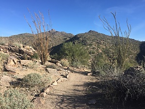
Believe it or not I actually did see a Javelina
by fricknaley

 Likely In-Season!
2013 Route Modification
Access is now from the Ritz.

Overview
This is a lovely, easily accessible out and back hike on the western edge of the trails in the western section of the Tortolita Mountains. It makes for a quick jaunt with enough up and down elevation to get your heart rate up.
Hike
Start from the common Wild Burro Trailhead on the east side of Dove Mountain Blvd. used to access all these trails in the western Tortolias. This hike's first stretch is the ubiquitous Wild Burro Wash walk of 1.35 into the interior of the Wild Burro Canyon. This is the same wash I've described for all the other hikes out here, so I won't go into detail again. You can follow the trail as it wanders along either side of the wash or walk the wash. After passing the foolish Ritz Carlton and State Trust boundary, you will come to the Wild Burro Trail intersection and several others at a signed intersection. This is about 1.35 miles from the trailhead. Hang a right onto the Upper Javelina Trail and start to almost immediately climb up the northern flanks of the Wild Burro Canyon walls. The trail heads back west somewhat as it climbs with views of the resort (lame). As it climbs, it crosses over a small but relatively steep drainage heading south. Cross over this and switchback up its western walls up higher onto the northern wall of the larger Wild Burro Canyon. The trail heads away from the canyon slightly as it continues north onto the canyon's hilly ridgeline. Just less than a mile from the Wild Burro trail's intersection, the Upper Javelina will split at a signed intersection with the Wild Mustang Trail, which heads right. Take the left fork onto the signed Upper Javelina trail. There is an unsigned trail intersection just before this, which is only indicated by a generic trail marker with the arrow pointing you right. I think the unsigned left here may take you down to the Ritz, but I'm not sure. In either event, look for the signed intersection of Upper Javelina and Wild Mustang, which is roughly 2.25 miles from the parking lot.

This next stretch of the upper Javelina trail will parallel the ridgeline of a small canyon spilling down west towards to north end of the resort and adjacent golf course, with nice views far out to the west. This minor canyon sits between the larger Wild Burro and Cochie Canyons. It initially climbs up the north wall of the ridgeline and then crosses over to the south flank at the highpoint before slowly descending back down to the desert floor. The descent is fairly gradual. Though the resort view is annoying, the local scenery around you as you descend is very nice typical desert mountain terrain and flora. At about 3.75 miles from the trailhead, the Upper Javelina trail comes to a gate at the resort boundary. You can pass through the gate and follow a path along the periphery of the resort, possibly all the way back to the mouth of Wild Burro Canyon, which I would not recommend due to the annoyance factor. I'm not entirely sure the path goes all the way back. I would recommend going back up the way you came. You get to add some elevation again on the way back, and the scenery is much, much better.

Check out the Official Route and Triplogs.

Gate Policy: If a gate is closed upon arrival, leave it closed after you go through. If it is open, leave it open. Leaving a closed gate open may put cattle in danger. Closing an open gate may cut them off from water. Please be respectful, leave gates as found.

Leave No Trace and +Add a Triplog after your hike to support this local community.

2010-02-12 fricknaley
    WARNING! Hiking and outdoor related sports can be dangerous. Be responsible and prepare for the trip. Study the area you are entering and plan accordingly. Dress for the current and unexpected weather changes. Take plenty of water. Never go alone. Make an itinerary with your plan(s), route(s), destination(s) and expected return time. Give your itinerary to trusted family and/or friends.

     Permit $$
    None


     Directions
    or
    or
     Road
    Paved - Car Okay

    To Wild Burro (Ritz) Trailhead
    From I-10 in north Tucson take Tangerine Road exit (#240) and head east. In about 5 miles the 1st stoplight you come to is Dove Mountain Blvd. Take left here and follow the road roughly 4 miles around the west end of the Tortolitas. Just past The Gallery is a small well-signed trailhead for Wild Burro Trail. This is on your right.

    From PHX (I-10 & AZ-51) 104 mi, 1 hour 37 mins
    From TUC (Jct 1-10 & Grant) 20.6 mi, 27 mins
    From FLG (Jct I-17 & I-40) 248 mi, 3 hours 43 mins
    page created by fricknaley on Feb 12 2010 3:13 pm
    helpcorrectionissue

    end of page marker