 Route Editor

| Guide | ♦ | 6 Triplogs | 0 Topics |
details | drive | permit | forecast | 🔥 route |
stats |
photos | triplogs | topics | location |
| 42 | 6 | 0 |
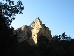
Seldom Used Spur by Jim   The H.S. Canyon Trail is a rarely hiked spur trail that branches off from the Secret Canyon Trail #121. If you are doing several short trails in the area, or you don't have time to do Secret Canyon but want to see some of the area, this may be a good option for you. If you can get to the Secret Canyon Trail, you can reach H.S. Canyon with ease. The only obstacle may be high water on the normally dry, Dry Creek. The day I did H.S., the creek was running with snowmelt, but it wasn't hard to get across. The H.S. Canyon Trail is a rarely hiked spur trail that branches off from the Secret Canyon Trail #121. If you are doing several short trails in the area, or you don't have time to do Secret Canyon but want to see some of the area, this may be a good option for you. If you can get to the Secret Canyon Trail, you can reach H.S. Canyon with ease. The only obstacle may be high water on the normally dry, Dry Creek. The day I did H.S., the creek was running with snowmelt, but it wasn't hard to get across.H.S. Canyon Trail is reached by taking the Secret Canyon Trail about 2/3 to 3/4 of a mile from the parking area. The first creek crossing is at the start of the Secret Canyon Trail, and the H.S. Canyon Trail junction is just after the second creek crossing. At the junction of the two trails, there is a small metal sign that marks the entrance to H.S., and it may be easy to miss if not paying attention.
I don't want to paint a picture that this is a horrible trail. I enjoyed my hike for the most part, and I can see this being a nice, quiet place to view and listen to neo-tropical migrants in spring. While relaxing at my turnaround point I had the pleasure of viewing and listening to a Western Scrub-Jay calling in its territory. It is very pretty back there, and if you find crowds irritating, it can be an isolated canyon to visit. It is worth a trip once, and autumn is probably a nice time of year as maples are numerous the further you go. As with all Sedona canyons, the late-day sun on the canyon walls is always a nice thing to see.
Coconino FS Details This is an infrequently used trail. It is sufficiently shaded to allow hiking in summer. Start on Secret Canyon Trail. Its signed trailhead is across the usually dry streambed of Dry Creek, west of the parking area. It immediately enters Wilderness. Follow this wide, nearly flat trail for 2/3 mile and look for the sign for HS Canyon Trail on the left. The trail climbs gradually in the shade of oak and alligator juniper. At about 1.5 miles from the parking area, views of red rock formations open up. The trail narrows further as it climbs moderately beside the small canyon drainage. At 2.25 miles, the trail approaches the sheer face of Maroon Mountain and switchbacks up to a small clearing for nice views of the mountain and the end of the box canyon. Return by the same route for a 5 mile rountrip hike. Check out the Official Route and Triplogs. Leave No Trace and +Add a Triplog after your hike to support this local community. One-Way Notice This hike is listed as One-Way. When hiking several trails on a single "hike", log it with a generic name that describes the hike. Then link the trails traveled, check out the example. | ||||||||||||||||||||||||||||||||||||||||||||||||||||||||||||||||||||||||||||||||||||||||||||||||||||||


