 Route Editor

| Guide | ♦ | 12 Triplogs | 0 Topics |
details | drive | no permit | forecast | route |
stats |
photos | triplogs | topics | location |
| 73 | 12 | 0 |
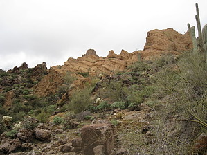
More than one knife's edge by AZLOT69  Caution CautionOff-trail hike. Route finding skills necessary. Overview This Goldfield area off-trail bushwhack heads up towards a feature that appears to be a mitten from a distance as seen from the Rough-N-Ready trail. Its appearance changes as you approach it and is caused by a series of hoodoos lined up just right. The feature that is most prominent as you approach the high point of this hike is a protuberance known as Razorback Knob. From the knob the 360-degree views of the area are spectacular. The hike can be done in either direction but starting in the morning, clockwise, as described here will keep the sun behind you. Hike The trailhead is marked by a single cairn on the Packsaddle Trail about one hundred yards west of the Rough-N-Ready trail. Starting on the right side of an unnamed wash you quickly cross over to the left side in about three hundred yards. There is no exact trail. Simply take the path of least resistance. This is quite easy to do due to limited vegetation and animal paths. Looking ahead pick a spot to aim for and serpentine back and forth to ease the grade. You may head for the saddle on the left for a nice view of Packsaddle from above. Continue towards the north contouring around the next high point ahead. If you keep gaining elevation at this point you will cliff out and have to give back some elevation to continue contouring around the next high point. Working higher and higher towards the northwest you top out with a dark monolith ahead. Take a low contour maintaining your elevation as you work westerly around the left side of this structure. Looking up a gun sight appears with the dark monolith on the right and blonde colored hoodoos on the left. These blonde hoodoos are the mitten. Continue to work yourself along the base of the blonde hoodoos to a slick rock chute up to a saddle. On your right is Razorback Knob. Enjoy the views from the saddle and climb the knob. While easy to climb the blonde rock, the dark rock that makes up the knob is a different story. It's brittle and would require climbing skills to get up the last twenty feet. It's a sharp drop-off from the knob on the north side. Incredible views are obtained from or near the top.
Check out the Official Route and Triplogs. Leave No Trace and +Add a Triplog after your hike to support this local community. One-Way Notice This hike is listed as One-Way. When hiking several trails on a single "hike", log it with a generic name that describes the hike. Then link the trails traveled, check out the example. | ||||||||||||||||||||||||||||||||||||||||||||||||||||||||||||||||||||||||||||||||||||||||||||||||||||||||||||||||||||||||||||||||||||||||||||||||||||||||||||||||||||||||||||||||||||||||||||


